|
||

|

|
|

|
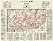
Interesting pictorial map of Waterford Town, Virginia, drawn by Clare B. Metzger for The Waterford Foundation.
The present map is based the official map of the town, commissioned in 1875. The Acts of 1875 provided that the Waterford council should have a survey and plan of the town made, showing its boundaries, public streets and alleys, with such explanations or remarks as they deemed proper. This resulted in the well-known map of 1875 by James S. Oden.
In 1943, the Oden map was used by artist Clare B. Metzger as the basis for a pictorial map which she drew of the town. It was printed and sold by the Waterford Foundation, tinted and framed copies of it hang in many Waterford homes.
Waterford and the Waterford Foundation
Waterford is a village in the Catoctin Valley of Loudoun County, Virginia. The entire village and surrounding countryside is a National Historic Landmark District, noted for its well-preserved 18th and 19th-century character.
Waterford was established around 1733 by Amos Janney, a Quaker from Bucks County, Pennsylvania. Janney purchased 400 acres on the south fork of Catoctin Creek and established a grist mill and saw mill in the area in the 1740s. The settlement became known as "Janney's Mill". Amos Janney died in 1747, leaving his estate to his sixteen-year-old son, Mahlon. Mahlon replaced the original log mill with a two-story structure. The village continued to grow, and in 1780, 12 acres on the south side of Main Street were subdivided into 15 lots, upon which shops and homes were built. By the 1790s, the village was known as Waterford.
By the start of the Civil War, the population of Waterford remained largely Quaker. As pacifists and abolitionists, the Quakers remained loyal to the Union throughout the war. Waterford was the scene of a fierce fight between the county's Unionist and Confederate partisan units, the Loudoun Rangers and White's Rebels, respectively. In those days, it was the home for mostly Quakers who helped slaves escape to the North.
After falling into disrepair in the early part of the 20th century, the Waterford Foundation was formed to help save and preserve Waterford and its history. In 1974, the Waterford Foundation helped create an innovative land preservation program in which the historic properties of Waterford are protected through open space and façade easements. More than 60 easements have been granted. The village was listed as a Virginia Historic Landmark in 1969. Waterford and a significant portion of its surrounding countryside was declared a National Historic Landmark in 1970.
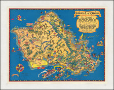
![[ Oahu ]](https://storage.googleapis.com/raremaps/img/small/101961.jpg)