|
||

|

|
|

|
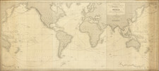
"All men are as grass and all their glory as flowers of the field. The wages of sin is death." Edward Luther Stevenson's Personal Facsimile of One of the Greatest Dutch World Maps Ever Made.
A fantastic facsimile of the Jodocus Hondius (or Jodocus Hondius II) 20-sheet world map, first published in Amsterdam circa 1611, celebrating the discovery of the the earliest known surviving example of the map in 1901 by Joseph Fischer.
The present map is a 1907 photographic facsimile of the 1618 edition of Hondius's 20-sheet map of the world, which had been discovered in a private castle library at Schloss Wolfegg in 1901. This photographic image was commissioned by the American Geographical Society and The Hispanic Society of America, under the supervision of American map scholar Edward Luther Stevenson. The printing of the image was was overseen by the well regarded American photographer Edward Bierstadt, shortly before Bierstadt's death in June 1906. The map was accompanied by a 19-page monograph, published in 1907.
The original 1611 Hondius map does not survive in any known examples. The earliest surviving example of the map is this 1618 state, which is known in a single example (illustrated here). A second surviving example, issued by Henricus Hondius in 1634, is known to survive in the collection of the Bibliotheque National de France. A third example is recorded, dated 1627, but is known to have been destroyed in 1906 during the San Francisco earthquake and ensuing fire.
Published by one of the two great cartographic publishing houses of the Golden Age of Dutch Cartography, 20-sheet Hondius World map is one of the great triumphs of the Hondius firm. It has been described by Ronald Shirley as "an outstanding masterpiece of cartographical engraving which may be considered to surpass even those wall maps of Blaeu (1605), Plancius (1607), and even Jodocus Hondius' own predecessor map of 1608 on Mercator's projection."
Because of the date of publication on the eve of Jodocus Hondius the Elder's death, there is some ambiguity surrounding the authorship of the map. Shirley notes that "Jodocus Hondius senior died in 1612 and it cannot be positively established whether the original map was by him or by his elder son of the same name."
The map is a supreme example of the mapmaker's art at a moment in time where wall maps were becoming an important part of the home and office decor of the European mercantile elite and aristocratic classes, comprising symbols of worldliness and curiosity during a moment in time when so much of the personal and state wealth accumulated in Western Europe was tied directly to overseas exploration and commerce.
Hondius's map benefits from the greatly expanding world view available to mapmakers of the early 17th Century, as a better understanding of viable trade routes to Southeast Asia came into view and exploration to the west began to focus on the importance of finding the shortest routes across the Atlantic Ocean and on to the riches of China and the Orient on the western shores of the Pacific Ocean.
Shirley says of the North American cartography: "In North America, Hondius has used the occasion to expound current theories postulating a vast inland sea west of present-day Virginia." This was in fact the early John Smith mapping of Virginia, which Jodocus Hondius had seen from Henry Hudson in 1608. The present map provides for the first time one of the most remarkable and short-lived theories of a direct route to the Pacific, an idea explored briefly by famed explorer John Smith and thereafter by Henry Hudson, consisting of a direct water course across North America immediately to the north of the Virginia Colony. The passage is meticulously described in this wall map by Hondius, by far the most elaborate depiction of Smith's theory.
In addition, the map includes information from Weymouth's expedition to Maine, Smith's early exploration of Virginia recounted in 1608, the 1609 Hudson voyage to Nova Zemblaya.
Another feature, which would be unique to this state of the map, is the inclusion of Schouten and Le Maire's 1617 discovery of a second passage from the Atlantic to the Pacific, to the south of the Straits of Magellan.
One of the most striking aspects of the map is its inclusion, in the upper-left quadrant, of a momento mori cartouche with death's own coat of arms. The text, in Latin, are the Biblical phrases: Peter 1:24 "All men are as grass and all their glory as flowers of the field." and Romans 6:23 "For the wages of sin is death; but the gift of God is eternal life through Jesus Christ our Lord." The cartouche takes on particularly poignance when it is considered that the map was made in the final year of Jodocus Hondius's life.
The present example of the map comes with a 19-page pamphlet edited by Edward Luther Stevenson and Joseph Fisher, published in 1907, which describes the production of the facsimile map:
The photographic negatives of the map, made in Feldkirch by the photographer Alois Gnädinger under the direction of Professor Gottfried Richen, S.J., were sent to Mr. Edward Bierstadt, New York City, and in his establishment, which is distinguished for the excellence of its work, the map has been artistically reproduced, faithful to the original in every detail. The printing of the map and of the descriptive text has been under the supervision of Professor Stevenson. The expense of the undertaking is jointly carried by The American Geographical Society and The Hispanic Society of America.
Rarity
The Stevenson-Bierstadt facsimile is a remarkable and rare artifact its time.
We note no examples on the market in dealer or auction catalogs recorded in RBH since 1938. The last example at auction was offered by Anderson Galleries in 1920. An example of the map was offered by Maggs Brothers in 1929 (Catalog 526, Item 369, offered for 42 GBP).
The Edward Luther Stevenson Collection
Edward Luther Stevenson was among the most important scholars of early cartography active at the end of the 19th century and the first half of the 20th. He was responsible for numerous cartobibliographic books, including the first translation of Ptolemy to English, as well as a series of impressive facsimile maps produced while he was at the Hispanic Society of New York. Dr. Stevenson viewed facsimiles as integral to the study of early cartography, and he committed himself to building an unparalleled collection of photographs of early maps and globes. Much of his collection was donated to Yale University after his death (click on the title link above for about that), but the present item comes from a large collection of photos, manuscripts, and related material that were part of Stevenson's library, but were not donated to Yale. It is truly an impressive collection and many of the items, though reproductions, have serious antiquarian merit. As Alexander O. Vietor said about Stevenson collection that went to Yale "this is the stuff of which great libraries are made."
Jodocus Hondius the Elder (1563-1612), or Joost de Hondt, was one of the most prominent geographers and engravers of his time. His work did much to establish Amsterdam as the center of cartographic publishing in the seventeenth century. Born in Wakken but raised in Ghent, the young Jodocus worked as an engraver, instrument maker, and globe maker.
Hondius moved to London in 1584, fleeing religious persecution in Flanders. There, he worked for Richard Hakluyt and Edward Wright, among others. Hondius also engraved the globe gores for Emery Molyneux’s pair of globes in 1592; Wright plotted the coastlines. His engraving and nautical painting skills introduced him to an elite group of geographic knowledge seekers and producers, including the navigators Drake, Thomas Cavendish, and Walter Raleigh, as well as engravers like Theodor De Bry and Augustine Ryther. This network gave Hondius access to manuscript charts and descriptions which he then translated into engraved maps.
In 1593 Hondius returned to Amsterdam, where he lived for the rest of his life. Hondius worked in partnership with Cornelis Claesz, a publisher, and maintained his ties to contacts in Europe and England. For example, from 1605 to 1610, Hondius engraved the plates for John Speed’s Theatre of the Empire of Great Britaine.
One of Hondius’ most successful commercial ventures was the reprinting of Mercator’s atlas. When he acquired the Mercator plates, he added 36 maps, many engraved by him, and released the atlas under Mercator’s name, helping to solidify Mercator’s reputation posthumously. Hondius died in 1612, at only 48 years of age, after which time his son of the same name and another son, Henricus, took over the business, including the reissuing of the Mercator atlas. After 1633, Hondius the Elder’s son-in-law, Johannes Janssonius, was also listed as a co-publisher for the atlas.
![[Early Facsimile] Carta Marina Navigatoria Portugalien Navigationes: atque tocius cogniti orbis terrae marisque formae naturam situm et terminos noviter recognitos et ab antiquorum traditione differentes hec generaliter monstrat, 1525](https://storage.googleapis.com/raremaps/img/small/66533.jpg)
![The Western Hemisphere... [with:] The Eastern Hemisphere A Stereographical Projection on the Twentieth Meridian](https://storage.googleapis.com/raremaps/img/small/97573.jpg)