|
||

|

|
|

|
Stock# 69814
Description
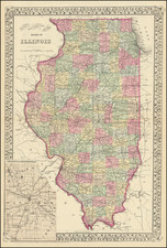
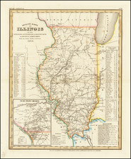
Rare early map of Illinois, published by Rufus Blanchard prior to his move to Chicago.
Includes a 'Table of Statistics' and 'Meridians and Baselines' in the lower left corner.
The map is printed using the cerographic printed method, an American invention attributed to the Morse family.
Condition Description
Folding map, packed with thick linen. Minor fold splits and a repaired tear running to Hancock County.