|
||

|

|
|

|
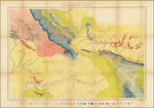
"Astonishing in the Quality of Its Detail" -- The Second Known Example of Colton's Comprehensive Mapping of the Central Pacific Route
Fine example of the second known example of GW & CB Colton's map of the Route of the Central Pacific Railroad.
The map prominently displays in red the route of the Central Pacific Railroad from San Francisco to just beyond Ogden Utah, where it connects to the Union Pacific route. A work of exceptional quality, historian Carl Wheat dedicates a 2-1/2 pages in Mapping of the Transmississippi West to the description of this map, which we have excerpted below:
After this long prefatory decision, which it is hoped will alert students to the important of any Union Pacific and Central Pacific survey maps . . .we shall allow various maps of 1867-1869 to complete the story of the building of the Pacific Railroad. [The first map discussed], thoroughly professional in its aspect, launches us upon our theme, a "Map Showing the Route of the Central Pacific . . . " published in 1867 by . . . Colton. To say the least, this is a map of spacious concept . . . covering the whole of the West, but even this portion clearly is of the highest caliber; the map is really astonishing in the quality of its detail. For instance, we have not previously seen a comparable wealth of fresh military fact offered by a commercial map. . . .
Wheat's observations on the many routes shown on the map is accurate. These include Mail Routes, military roads, explorers routes and traders routes ,dotted with early western forts, settlements and observations on the lands. Interesting, Wheat notes in his footnote 18 to the map that while he was initially convinced that the map was drawn from a larger map by Colton, his request to the Library of Congress Map Division to assist in locating the source map was unsuccessful, and indeed the sole known example until the discovery of this example was the copy located by Wheat at the Bancroft Library at UC Berkeley.
The map's remarkable detail is not limited to the area along the Central Pacific Route. For example, the detail in Southern California and Arizona, is quite extraordinary. One of the more unusual features is the demarcation of numerous mining regions (see for example the area around Prescott, Arizona), even in unexpected places like Little Bear Valley and Holcomb Valley in the San Bernardino Mountains.
The map also notes recent gold discoveries, such as the recent gold discoveries in the area of Boise, Idaho.
The second known example of this extraordinary rarity.
Rarity
OCLC locates one example: Bancroft Library.
G. W. & C. B. Colton was a prominent family firm of mapmakers who were leaders in the American map trade in the nineteenth century. The business was founded by Joseph Hutchins Colton (1800-1893) who bought copyrights to existing maps and oversaw their production. By the 1850s, their output had expanded to include original maps, guidebooks, atlases, and railroad maps. Joseph was succeeded by his sons, George Woolworth (1827-1901) and Charles B. Colton (1831-1916). The firm was renamed G. W. & C. B. Colton as a result. George is thought responsible for their best-known work, the General Atlas, originally published under that title in 1857. In 1898, the brothers merged their business and the firm became Colton, Ohman, & Co., which operated until 1901, when August R. Ohman took on the business alone and dropped the Colton name.
![[ English Plantations in North America ] A New Map of the most Considerable Plantations of the English In America Dedicated to His Highness William Duke of Glocester.](https://storage.googleapis.com/raremaps/img/small/98233.jpg)
![[ San Francisco Bay, North Coast & Monterey Bay Region ] Amer. Sep. No. 46 Nouvelle Californie](https://storage.googleapis.com/raremaps/img/small/98751.jpg)
![[Poster] IBM Advertising - Boulder, Colorado](https://storage.googleapis.com/raremaps/img/small/78793.jpg)