This item has been sold, but you can enter your email address to be notified if another example becomes available.


|
||

|

|
|

|
Stock# 69786
Description
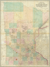
Large Minnesota Historical Society pictorial map depicting the Territory of Minnesota in 1849.
The main map focuses on the roads in the Territory in 1849, an inset map shows the original counties, and another shows the roads in eastern Minnesota in 1855.
Imperfect example of a nice mid-century pictorial of Minnesota.
Condition Description
Some edge damage and torn corners.
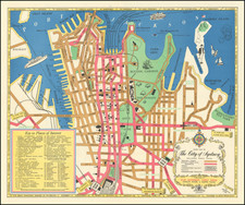
![[Melbourne, Australia] We show you Melbourne City, but from a dizzy height. Come see it as we know it, you'll vote it very bright!](https://storage.googleapis.com/raremaps/img/small/94298.jpg)