


|
||

|

|
|

|
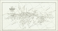
The First Appearance of the Great American Desert -- A Foundational Map of the American West
Scarce map of the region from the Rocky Mountains to the Mississippi Valley, which accompanied the English edition of Stephen Long's important report on his expedition to the Rocky Mountains.
Long's map illustrates the region drained by the Arkansas, Kansas, Missouri & Mississippi Rivers, one of the most important expeditions of the American West from the first half of the 19th Century. A daily account of Long's route is shown on the map, beginning west of Council Bluff on June 7, traveling west to the Pawnee Villages and then south to the Platte River and finally to the Rocky Mountains by the first week in July, then south to the Arkansas River. The party then proceeded eastward, before splitting into two groups on July 24, with Captain Bell's detachment proceeding east via the Arkansas and Major Long's detachment traveling south the Canadian River and then returning east to the Indian Territory.
The map also shows the location where the detachment led by Thomas Say was robbed by a Pawnee War Party, near the Konzas Villages.
Stephen H. Long led a Government expedition to the Rocky Mountains in 1819 and 1820. Following on the heals of the Lewis & Clark expedition, it is generally regarded as one of the most important early overland expeditions to the American West, following the completion of the Adams Onis Treaty.
This map was prepared to illustrate the London edition of the official account of Long's expedition, Account of an Expedition from Pittsburgh to the Rocky Mountains, published in London in 1823. While the map was produced by Long, the report of the expedition was written by Edwin James, the botanist who accompanied Long. Other members of the expedition were Thomas Say as naturalist and entomologist, and Titian Peale as draughtsman.
Wheat noted that the map represented a distinct step forward in the mapping of the West, the first to use the term Great American Desert. It corrected many errors, primarily the course of the Red River, and the corrections to the eastern slope of the Rocky Mountains. HS Tanner also spoke highly of the map in his 1823 Geographical Memoir.
Stephen Harriman Long Expedition
In 1814, Long was commissioned a lieutenant of engineers in the U.S. Army Corps of Engineers. Upon the reorganization of the Army in 1816, he was appointed a Major on 16 April and assigned to the Southern Division under Maj. Gen. Andrew Jackson as a topographical engineer.
In 1817, Major Long headed a military excursion up the Mississippi River to the Falls of St. Anthony near the confluence with the Minnesota River. As a result of his recommendations, the Army established Fort Snelling to guard against Indian incursions against settlers in the Upper Mississippi Valley.
In 1818 he was appointed to organize a scientific contingent to accompany soldiers of Colonel Henry Atkinson's command on the Yellowstone Expedition (sometimes called the Atkinson-Long Expedition). The plan was to explore the upper Missouri River. Long spent the autumn designing the construction of an experimental steamboat for the venture, Western Engineer. Departing from St. Louis in June 1819, it was the first steamboat to travel up the Missouri River into the Louisiana Purchase territory, and the first steamboat to have a stern paddle wheel. On September 17, Long's party arrived at Fort Lisa, a trading fort belonging to William Clark's Missouri Fur Company. It was about five miles south of Council Bluffs, Iowa. Long's group built their winter quarters nearby and called it "Engineer Cantonment."
Within a month, Long returned to the east coast, and by the following May, his orders had changed. The Yellowstone Expedition had become too costly and so instead of exploring the Missouri River, President James Monroe decided to have Long lead an expedition up the Platte River to the Rocky mountains and back along the border with the Spanish colonies. Exploring that border was vital, since John Quincy Adams had just concluded the treaty with Spain, which drew a new U.S. border to the Pacific.
The party ascended the Platte River and explore the headwaters of both the Red River and Arkansas River. The expedition followed the Platte River to the South Fork to the Colorado Rockies, where they discovered and named Long's Peak. On July 5, 1820, they reached present day Denver and on July 12, Colorado Springs, from which three party members, including Edwin James, set out to climb Pike's Peak.
The party continued south to the upper Arkansas River, where Long divided it into two groups. One group was instructed to continue the exploration of the Arkansas while the second group, which included both Long and James, went to explore the Red River. In early August the party followed the Canadian River, mistaking it for the Red. This mistake led the group into New Mexico and the Texas panhandle, where they suffered from a scarcity of food sources. The expedition also encountered a party of Kiowa-Apaches, the first recorded meeting between Anglo-Americans and Kiowa-Apaches. The group traveled through Oklahoma and finally reunited with the others at Fort Smith, Arkansas.
The expedition ended with neither of its main objectives met. Neither the source of Arkansas nor the Red River was found. The geographic details of the "Great American Desert" were hardly what an expansionist government wanted to hear about. Nevertheless, the Long Expedition was the first scientific survey of the region and dramatically increased the country's geographical knowledge of the West.
Rarity
While the complete report appears on the market occasionally, the separate map is quite rare on the market. This is the first example we have offered for sale.
Long attended Dartmouth and entered the Army in 1814 as a Second Lieutenant of Engineers. After teaching mathematics at West Point he went west to explore the Upper Mississippi. In 1819 he was ordered to explore the Rocky Mountains, for which he became well known. He had a celebrated and very distinguished career with the Army Topographical Engineers.
![(Native American Photograph) [Fox On The War Path (Ke-wuk-o-car-war-ry), a Pawnee man of Indian Territory]](https://storage.googleapis.com/raremaps/img/small/93109.jpg)
![[Montana, Wyoming, Dakota, Upper Missouri River] Amer. Sep. No. 40. Partie des Etats Unis](https://storage.googleapis.com/raremaps/img/small/93546.jpg)