


|
||

|

|
|

|
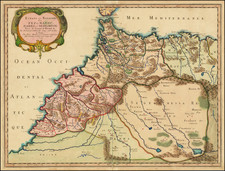
Nice full-color example of Ortelius's map of coastal North Africa and the Mediterranean, from his Theatrum Orbis Terrarum, the first modern atlas of the world.
The map extends from Morocco and the Sahara to Libya and shows most of the Mediterranean, including the Balearic Islands, Sicily, Corsica, Sardinia, and Italy, along with the Canaries off the coast of Africa. Detail in central Africa is largely down to myth and legend, with a number of cities shown, many rivers and lakes, and even copious notes. Some of these cities, although incorrectly placed, are not completely fictional. Guargala, described as a "city elegantly built," is now known as Ouargla and is one of the largest cities in the Algerian portion of the Sahara.
The map is decorative, with simple stylistic tendencies commonplace in Ortelius's early maps. In the Mediterranean, a majestic sea monster is seen, a dolphin hybrid is off the coast of Lisbon, and a large ship is found under the text reading Golfo de las Yeguas.
Ortelius based his map on one published by an anonymous mapmaker in Venice in 1560, which itself was based on Gastaldi's 1556 map of Africa.
Abraham Ortelius is perhaps the best known and most frequently collected of all sixteenth-century mapmakers. Ortelius started his career as a map colorist. In 1547 he entered the Antwerp guild of St Luke as afsetter van Karten. His early career was as a business man, and most of his journeys before 1560, were for commercial purposes. In 1560, while traveling with Gerard Mercator to Trier, Lorraine, and Poitiers, he seems to have been attracted, largely by Mercator’s influence, towards a career as a scientific geographer. From that point forward, he devoted himself to the compilation of his Theatrum Orbis Terrarum (Theatre of the World), which would become the first modern atlas.
In 1564 he completed his “mappemonde", an eight-sheet map of the world. The only extant copy of this great map is in the library of the University of Basel. Ortelius also published a map of Egypt in 1565, a plan of Brittenburg Castle on the coast of the Netherlands, and a map of Asia, prior to 1570.
On May 20, 1570, Ortelius’ Theatrum Orbis Terrarum first appeared in an edition of 70 maps. By the time of his death in 1598, a total of 25 editions were published including editions in Latin, Italian, German, French, and Dutch. Later editions would also be issued in Spanish and English by Ortelius’ successors, Vrients and Plantin, the former adding a number of maps to the atlas, the final edition of which was issued in 1612. Most of the maps in Ortelius' Theatrum were drawn from the works of a number of other mapmakers from around the world; a list of 87 authors is given by Ortelius himself
In 1573, Ortelius published seventeen supplementary maps under the title of Additamentum Theatri Orbis Terrarum. In 1575 he was appointed geographer to the king of Spain, Philip II, on the recommendation of Arias Montanus, who vouched for his orthodoxy (his family, as early as 1535, had fallen under suspicion of Protestantism). In 1578 he laid the basis of a critical treatment of ancient geography with his Synonymia geographica (issued by the Plantin press at Antwerp and republished as Thesaurus geographicus in 1596). In 1584 he issued his Nomenclator Ptolemaicus, a Parergon (a series of maps illustrating ancient history, sacred and secular). Late in life, he also aided Welser in his edition of the Peutinger Table (1598).
![Egypt called in the Country Missir by Monsr. D'Anville of the Royal Academy of Belles Lettres, & of that of Siciences [sic] of Petersburg Secretary to H.S.H. the Duke of Orleans. MDCCLXV.](https://storage.googleapis.com/raremaps/img/small/49130.jpg)
![[Africa] Tabula II Aphricae. (title on verso) (shows Malta and part of Sicily and Sardinia)](https://storage.googleapis.com/raremaps/img/small/103261.jpg)
![[Conquest of Tunis] Benigni Lettori, per rappresentarui, piu particulari della Citta di Tunesi, holla tenuta alquanto piu larga di quello che importa la pianta di ess Citta . . . M. D. LXVI](https://storage.googleapis.com/raremaps/img/small/75025.jpg)