|
||

|

|
|

|
Stock# 69734
Description
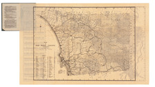
Rare Wall Map of the South Bay
Interesting map of the area south of San Diego, extending from National City to Tijuana, centered on Chula Vista.
The map covers what is today Imperial Beach, National City, Chula Vista, San Ysidro, and Bonita, however, when it was made it the area was relatively sparsely populated and the grinding and subdivision of land was fairly new.
An exceptionally detailed map of the South Bay.
Rarity
The map is unrecorded. We are aware of no other surviving examples.
Condition Description
Wall map on linen with original rollers. Toned at bottom edge.
![[ Ocean Beach / Point Loma ] Map of Point Loma Electric Railway](https://storage.googleapis.com/raremaps/img/small/96377.jpg)
![(California Pictorial Lettersheet) [Manuscript letter on Lettersheet with Bird's-eye view of Stockton, California]](https://storage.googleapis.com/raremaps/img/small/97542.jpg)
![[Eastern San Diego County] Cuyamaca Quadrangle](https://storage.googleapis.com/raremaps/img/small/83422.jpg)