This item has been sold, but you can enter your email address to be notified if another example becomes available.


|
||

|

|
|

|
Stock# 69732
Description
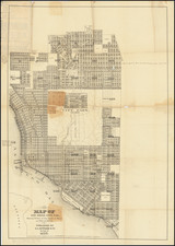
Large wall map of San Diego, showing Downtown, Balboa Park, and the neighborhoods of North Park, Banker's Hill, Little Italy, Mission Hills, and with an inset of Coronado.
This is a very large and detailed wall map of central San Diego, shown at 1:400 ft.
The map includes extensive plot-level detail, as well as information about the additions and subdivision within the city.
The map was probably originally published in the 1920s, with this example an updated state from November 1943.
Condition Description
Mounted on linen and original dowels. Toning at the top and bottom of the map, with a few small spots of loss.
![[ Coronado Beach Broadsheet ] Map of Coronado Beach San Diego, California / Coronado Beach and Surrounding Country](https://storage.googleapis.com/raremaps/img/small/99912.jpg)
![[San Diego] Views of Southern California. Prominent Places in and about San Diego](https://storage.googleapis.com/raremaps/img/small/69182.jpg)
![(San Diego - Pacific Beach) R. O. W. Map of the Pacific Beach Railroad [Old Town, False Bay, Grand Ave. to Broulett's or Brouillette's Addition]](https://storage.googleapis.com/raremaps/img/small/97271.jpg)