
This item has been sold, but you can enter your email address to be notified if another example becomes available.


|
||

|

|
|

|
Stock# 69731
Description
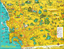
Large wall map of the San Diego Metropolitan Area, from Coronado to El Cajon, with an inset of Pacific Beach and La Jolla, and a further inset of the County of San Diego.
This is a very large and detailed wall map of central San Diego, shown at 1:4000 ft.
The map was initially issued in 1929, then updated in 1940 and 1943.
Most street names are recorded, though the city is far less developed than it is today. For instance, the interior of La Jolla, on Mount Soledad, and much of Chula Vista have little or no development.
Early wall maps of San Diego are quite rare.
Condition Description
Mounted on linen and original dowels. Toning at top and bottom of the map.
![[Mission San Luis Rey] Vue de La Mission de Saint Louis Roi De France](https://storage.googleapis.com/raremaps/img/small/71720.jpg)
![[La Jolla Farms / Scripps Institute of Oceanography] Referee's Partition Map of Pueblo Lots 1312 and 1313 of the City of San Diego, California, as made in accordance with an order from the Superior Court of San Diego County California, made in the action entitled Winnifred Murtha et al vs. Louis D. Radgesky, et al. . . .](https://storage.googleapis.com/raremaps/img/small/77020.jpg)