|
||

|

|
|

|
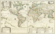
Massive world map in two large sheets published by Scandinavian Airlines and printed by the Esselte Map Service. The map was produced in Stockholm in 1971.
As SAS was (and is) based in Stockholm and many of its routes flew over the pole, SAS mapmakers tended to favor polar projections as they showed how close SAS's hubs were to their global destination. In this case the map is projected on the EMS Nr. 1 projection with Northern Hemisphere on a Polar Stereographic Projection and the Southern Hemisphere on a Conventional Projection (with Antarctica and certain ocean sectors excluded).
The map also includes detailed insets of Scandinavia in the lower right and Europe in the lower left.
Rarity
This is the first time we have seen the map. We can find no copies in OCLC nor anywhere online.
![[ Mapping The World's Telegraph Lines ] Planisphere Terrestre Indiquant Les Lignes Modernes de grande Communication par terre et par me Chemins De Fer - Paquebots-Telegraphie Electrique. . . . 1878](https://storage.googleapis.com/raremaps/img/small/98800.jpg)
![[Early Facsimile] Carta Marina Navigatoria Portugalien Navigationes: atque tocius cogniti orbis terrae marisque formae naturam situm et terminos noviter recognitos et ab antiquorum traditione differentes hec generaliter monstrat, 1525](https://storage.googleapis.com/raremaps/img/small/66533.jpg)