
This item has been sold, but you can enter your email address to be notified if another example becomes available.


|
||

|

|
|

|
Stock# 69646
Description
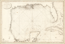
Scarce coast to coast map of the United States, showing a massive Texas and Upper California, both recently part of the United States, published in London in 1848.
Texas is shown 2 years prior to statehood, with a massive oversized northwestern extension into New Mexico Territory.
The rest of the west is "New California" (including New Mexico, Utah, Colorado, Nevada and Arizona), along with a massive Oregon Territory. Mythical Rio Buenaventura and Rio Sacramento are still shown.
Further north, the map includes an oversized Nebraska Territory, Dakota Territory and Wisconsin Territory.
This is the post-annexation Texas / pre-statehood configuration we have seen.
![Index Map of the Civil Code of California Designed and Executed By Curtis Lindley . . . [bound into] Revised Laws of the State of California; In Four Codes: Political, Civil, Civil Procedure and Penal . . .](https://storage.googleapis.com/raremaps/img/small/84298.jpg)
![(Dallas, Texas) USAF Target Complex Mosaic-Series 25 [Sheets 0 - 4]](https://storage.googleapis.com/raremaps/img/small/87119.jpg)

![[German Northern Pacific Promotional Tract] Die Nordliche Pacific Eisenbahn; Ihre Route, hulfsquellen, fortschritte & Gefchafte. der neue Nord-Westen und seine grosse Verkehrs-Strasse.](https://storage.googleapis.com/raremaps/img/small/83777.jpg)