


|
||

|

|
|

|
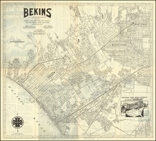
Rare Early Los Angeles Transit Lines Map
Fascinating transportation map of Los Angeles, highlighting the lines of the Los Angeles Transit Company.
The map very interesting, in that it provides one of the final snapshots of Los Angeles before the Automobile Industry completely remade the Los Angeles transit scene.
The map provides a fine overview of the street car, trolly and bus lines operating in Los Angeles immediately after World War II and immediately before the automobile industry completely remade the Los Angeles transit landscape.
Operating lines include:
- LA Transit Trolleys
- LA Transit Coach
- LA Transit Car Lines
- Los Angeles Motor Coach Lines
- Pacific Electric Railway Local Car Lines
- Pacific Electric Railway Local Car Lines
The numbers and letters on the map are keyed to explanations on the verso, giving additional details on the various lines, and highlighting arks and tourist attractions around Los Angeles.
The opening of the Arroyo Seco Parkway in 1940, linking Downtown Los Angeles and Pasadena with the first of what would be a network of freeways. Over the next decades, the car culture flourished in Los Angeles. America's automotive industry successfully conspired to emasculate LA's public transportation system, buying up and ending the street car bus and trolley service which had previously served LA and advocating the construction of auto-friendly roads. Within only a short time after this map, public transportation in LA would be nearly completely wiped off the map.
![[Southern California Citrus Fair Promotional Broadside] Riverside Exhibit / Removed From Riverside Cal. to Armory Hall, Los Angles, Open Day & Eve'ng from Feb 29 to March 6th 1888](https://storage.googleapis.com/raremaps/img/small/74529.jpg)
![[Los Angeles Olympic] O Limp Hicks Loose Anglaise Calif. 1932](https://storage.googleapis.com/raremaps/img/small/90509.jpg)
![(Los Angeles Architecture) [Photograph of a 1920s Spanish Colonial Revival home, likely in the Hollywood Hills area; with glass plate negative]](https://storage.googleapis.com/raremaps/img/small/96755.jpg)
![[Los Angeles] Metro Greenline](https://storage.googleapis.com/raremaps/img/small/96817.jpg)