


|
||

|

|
|

|
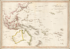
Detailed Chart of the Southwestern Pacific from the La Perouse Atlas
Intriguing chart of Eastern Australia and part of the southwestern Pacific, showing the route taken by the Spanish explorer Don Francisco Antonio Mourelle in 1781 along the northern coast of New Guinea to Tonga.
The chart was published in the atlas that accompanied an account of the lost La Perouse expedition (1785-88), which was published in 1797. At that time, La Perouse’s fate was still unknown; his ships would only be found thirty years after the chart was published.
The chart reads left to right, as Mourelle’s Princesa sailed through what is now called the Bismarck Archipelago near New Guinea east through the Solomons and on to the Iles des Amis, or the Friendly Islands, an early European name for Tonga. Mourelle is credited with being the first European to encounter the excellent anchorage at Vavao (Vava’u). The track of Mourelle than tacks south, to the I de. Vasquez and then north off the chart.
Other islands of note include Fidji (Fiji), which has a note erroneously identifying European contact with Tasman as taking place in 1743, rather than 1643. It also notes that William Bligh, famous for the mutiny against him, visited in 1789.
In the lower left corner is the northeastern coat of Australia. It shows the coastline first surveyed by James Cook and later by La Perouse himself. There are still gaps in the shore, especially where the Great Barrier Reef made sailing treacherous.
In the center of the chart are Nouvelle Caledoniae (New Caledonia) and the Archipel du St. Esprit, also known as the New Hebrides and today as Vanuatu. The latter is where Pedro Ferdinand de Quiros landed in 1606. He thought he had discovered a fertile southern continent and tried to found a city, Nueba Jerusalem. His crew convinced him to abandon the would-be colony, but Quiros remained obsessed with the place until his death.
A note on the chart states that the publisher has placed the islands according to the longitude of other navigators, rather than on Mourelle's figures which were only considered estimates. It also states that Mourelle used a chart by Jacques Nicholas Bellin, published in 1742, for his charting, with the implication that this later chart could place things more accurately.
The Pacific voyages of Antonio Mourelle
Francisco Antonio Mourelle de la Rúa (1750-1820) (sometimes written Maurelle) was a Spanish naval officer. He first served in the Caribbean before being transferred to the naval station at San Blas, New Spain, on the Pacific coast. Mourelle was part of the Bruno de Heceta and Juan Francisco de la Bodega y Quadra expedition up the California coast in 1775. With Bodega y Quadra in the Sonora, Mourelle traveled to 58°30’ north. Somehow, Mourelle’s journal was secreted to London, where it was published and used by Cook on his third voyage.
Mourelle again accompanied Bodega y Quadra on another Pacific Northwest expedition in 1779. This time, in the Favorita, they reached 61°N and sailed in the Gulf of Alaska and along the Kenai Peninsula.
In 1781, on the Princesa, Mourelle sailed to the western Pacific in an attempt to find a southerly route from the Philippines to New Spain. En route, he charted and was credited with the discovery of the Hermit Islands. His ultimate goal was thwarted by winds, however, and he sailed east via Guam and the northern route to Mexico.
Mourelle was to sail as part of the Malaspina expedition when it was in the Pacific Northwest, but other officers were selected instead. In 1793 he was called to Spain where he served during the Napoleonic Wars.
The La Perouse expedition (1785-1788)
Inspired by the success and popularity of James Cook’s three voyages, the French planned their own expedition of Pacific discovery in 1785. The commander chosen by Louis XVI to lead the voyage was Jean-Francois de Galaup, Comte de La Perouse (1741-ca. 1788). At fifteen, La Perouse had joined the French Navy as a marine and he enjoyed promotion during the actions of the Seven Years’ War. In the 1770s he served in the Indian Ocean and, in the early 1780s, in Hudson’s Bay during the American Revolution.
La Perouse was to carry on where Cook left off, exploring the western Pacific and continuing to look for a Northwest Passage. He set off from Brest in August of 1785 in command of the Boussole, with Paul-Antoine-Marie Fleuriot de Langle accompanying in the Astrolabe. They headed across the Atlantic, round Cape Horn, with stops at Easter Island and Hawaii. From there, La Perouse navigated to the coast of what is now Alaska, where La Perouse agreed with Cook that there was no Northwest Passage entrance along that coastline.
La Perouse returned south, to Monterey Bay, California, before heading across the Pacific to Macao, then a Portuguese colony. From there, they sailed to Manila, Formosa (Taiwan), the Ryukyu Islands, and between Korea and Japan. Then, La Perouse ventured farther north to Petropavlovsk on the Kamchatka Peninsula.
Having received word of a new British colony in southeast Australia, La Perouse sailed south, searching for the long misplaced Solomon Islands on the way. At Tutuila, in what is now American Samoa, twelve of the crew were killed in an altercation with indigenous peoples. This was not the last misfortune to befall the voyage.
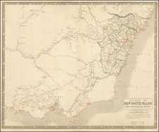
La Perouse arrived at Botany Bay, now Sydney, in January of 1788. He observed the nascent penal colony and then returned to the western Pacific, near the Gulf of Carpentaria. En route he and his ships disappeared without a trace.
Two years later, in 1791, Antoine-Raymond-Joseph de Bruni, chevalier d’Entrecasteaux, was sent to find out what had happened to La Perouse and his men. He made several discoveries but not anything related to La Perouse’s ships or crew. In 1826, an Irish captain, Peter Dillon, was in the Santa Cruz group and came across several French swords which locals told him came from two large ships that had broken up on reefs.
Only in 1828 did another French expedition, commanded by Jules-Sebastien-Cesar Dumont D’Urville, locate traces of the Astrolabe near the island of Vanikoro. It seems La Perouse and his ships wrecked on the island; survivors may have tried to sail in a small craft to Australia, but none were ever found. In 1964, archaeologists located the wreck of the Boussole in the waters off Vanikoro.
Partially because of the scope of the voyage and the popularity of Pacific exploration, and partially because of his mysterious disappearance, La Perouse was the most famous French explorer then and continues to be to this day.
His voyage’s story was told based on materials he managed to send back from Macao, Petropavlovsk, and Botany Bay. These journals and manuscripts, including many charts in an accompanying atlas, made up the source material for an account of the voyage published in Paris in 1797.
![Entree de la Riviere Endeavour dans la Nle. Galles Merid. [with] Baye de Botanique dans la Nle. Galles Meridionale](https://storage.googleapis.com/raremaps/img/small/77737.jpg)
![[ Australia ] Australien](https://storage.googleapis.com/raremaps/img/small/98068.jpg)