|
||

|

|
|

|
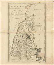
Manuscript Map Showing the New Hampshire Grants Which Would Become The State of Vermont
Finely executed manuscript map delineating the New Hampshire Grants, the first meaningful delineation of the future state of Vermont.
The map extends north to Lake Champlain, east to the Connecticut River and south to the Massachusetts-Vermont boundary line. The vertical line, running from the Massachusetts border to the area just east of Lake George shows an early depiction of the Vermont-New York boundary. The river shown running north and south at the top of portion of the map is Otter Creek, with the map extending north to about Ferrisburgh and Montpelier.
The map is drawn on handmade paper with a watermark which would suggest that the paper was made sometime in the second half of the 18th Century (a variant of the relatively common D&C Blauw watermark).
During the colonial period, this land belonged to New York, but between 1749 and 1764, New Hampshire Governor Benning Wentworth sold off the land for monetary gain. In 1757, Wentworth had a survey made of the 108 grants he had issued in the territory extending 60 miles up the Connecticut River, westward to 20 miles east of the Hudson (the vertical line drawn in the center of the map).
In order to expand his land and offer new land to the settlers in his colony, on January 3, 1749, Governor Wentworth declared a previously uninhabited area to be reclaimed on the western bank of the Connecticut River as part of the colony of New Hampshire, which he named Bennington, after his own first name, and sold the lands to interested settlers. This sparked protests from New York, which claimed the areas on the west bank of the Connecticut River under a grant from King George III Wentworth then stopped the settlement to await another decision by the King, which did not materialize.
In two large settlement campaigns in 1755 and 1757, a total of 108 sections of land were declared for settlement and sold, covering lands along the west bank of the Connecticut River to the north and to about 20 miles east of the Hudson River. By 1762, the settled lands extended to Lake Champlain. By 1764 a total of 135 sections had been granted.
At the same time, New York began selling lands to the west. New York divided the areas differently, selling much larger tracts. This created a class difference in the settler structures. While the settlers on the New Hampshire side were mostly medium-sized farmers, on the New York side it was more wealthy landlords and large landowners who bought the land. The dispute escalated between the colonies of New York and New Hampshire.
In March 1764, King George finally decided the dispute in favor of New York. By royal decree of July 26, 1764, the New York colony was given the area between the west bank of the Connecticut River and the Hudson River and the northern border of the colony Massachusetts awarded up to the 45th parallel (today's border with Canada).
New York declared Wentworths' land sales invalid and offered them to the settlers to buy again, unless the land had already been sold to other owners. This led to considerable, civil war-like unrest, the formation of civil militias and a paramilitary unit, the Green Mountain Boys, under the leadership of Ethan Allen. Following the Revolution, the dispute was finally settled and the New Hampshire Grants in 1791 became Vermont, the 14th state of the United States.
Provenance
The map was acquired in October 2020 at Brunk Auctions, as a part of a collection of printed and hand drawn sea charts and maps from the descendants of James Sever, Captain of the USS Congress, one of the famed first six frigates of the U.S. Navy. Captain Sever was born in 1761, attended Harvard, and upon graduation received an ensign’s commission in the 7th Massachusetts Regiment in February, 1781, during the Revolutionary War. Sever later transferred to the 4th Massachusetts Regiment and remained in the Continental Army until June 1784.
Sever was from a successful Massachusetts merchant family, and that background along with his military experience was enough for him to be named the superintendent of the USS Congress during its construction in 1795. In 1798, he became one of the first six post captains of the U.S. Navy. Sever in fact served in the first foreign action of the U.S. Navy, when the Congress was involved in privateer hunting in the Caribbean and the U.S. intervention in the Haitian War of Knives. Sever had a relatively short career in the Navy and was dismissed during Jefferson’s purge of the officer corps in 1801.
Rarity
18th Century hand drawn American maps are very rare on the market. The connection to a famous American Sea Captain is quite intriguing.
While a number of the printed sea charts in the collection referenced above were signed, this map was unsigned.