|
||

|

|
|

|
An Early Manuscript Map of Present-Day New York City with Provenance to One of the U.S. Navy's First Frigate Captains
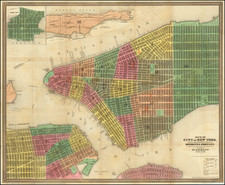
An early manuscript map of what is now New York City, based closely on William Bradford's New Map of the Harbour of New York, one of the great rarities of eighteenth-century American cartography.
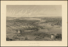
The Bradford map (illustrated as the second image above), like the present manuscript, depicts New York and northeastern New Jersey from roughly present-day Marlboro Township in the southwest to Little Falls in the northwest to Larchmont in the northeast and Far Rockaway in the southeast. It includes extensive bathymetric data for the harbor of New York, including dozens of soundings and stippled renderings of banks and shallows. The many place names are a mix of Native American, Dutch, and English, reflecting the region's recent history. They demonstrate how European settlement, originally confined to Manhattan Island, had long since spilled over into present-day Westchester County, Long Island, and New Jersey.
The only known copy of the printed Bradford map was purchased by Henry E. Huntington along with the entire library of E.D. Church in April 1911. The map was bound into a copy of the Chart of the City of New York printed by John Peter Zenger in 1735.
Bradford's map was advertised by in The New-York Gazette of March 24-31, 1735:
There is now Published a new Map of the harbour of New-York, from a late Survey, containing the Soundings and setting of the Tydes, and the bearings of the most remarkable Places, with the Proper Places for Anchoring [shown on the map by Roman numerals]. To be Sold by the Printer hereof.
The map was, for its time, by far the best cartographic depiction of the area; it was not exceeded until the charts of Des Barres, Ratzer, and others in the 1770s.
Comparison of the printed Bradford map and the manuscript
Though our manuscript is based closely on the Bradford, there are a number of interesting differences worth noting.
Bradford map: Manuscript map:
The title reads "New Map... by a late Survey" Title reads "Map... by Survey"
No ferry at south end of Staten Island Ferry added
"Schuiler's Copper Mine" "Scuylers Copper Mine"
"Brookland" "Bramland"
Includes the Roman numerals for anchorages Does not include anchorages
5-mile scale 15-mile scale
Our manuscript also includes a note not present on the Bradford map: “The Figures are for the depths of water.” This strongly suggests that the map was drawn for someone unfamiliar with the conventions of navigation charts.
It is also worth noting that the present manuscript has also been associated with Carwitham's A Plan of the Harbour of New York (circa 1735). While these maps do have strong similarities, the place names and bathymetric data on the manuscript are much more closely related to Bradford's map.
Dating the Manuscript
The map can be roughly dated to between 1735 and probably not later than the 1770s. The terminus post quem can be determined from the publication of the printed William Bradford from which this map is clearly derived. The map was probably not executed later than the 1770s when a number of very good charts of New York Harbor were published, rendering the earlier treatments obsolete.
The laid paper on which the map is drawn is watermarked with the coat of arms of either George II or George III and countermarked with a crowned GR. This is a fairly generic English watermark from the eighteenth century and does not enable us to tighten the map's dating.
However, the fact that the draftsman of the manuscript has changed the wording of the title from "New Map" and "Late Survey" to "Map" and "Survey" suggests that he was aware that the map was not hot-off-the press when he adapted it.
In all, this is a remarkable eighteenth-century survival, with a close but intriguing connection to William Bradford's unobtainable New Map of the Harbour of New-York.
Provenance
The map was acquired in October 2020 at Brunk Auctions as a part of a collection of printed and hand drawn sea charts and maps from the descendants of James Sever, Captain of the USS Congress, one of the famed first six frigates of the U.S. Navy. Captain Sever was born in 1761, attended Harvard, and upon graduation received an ensign’s commission in the 7th Massachusetts Regiment in February, 1781, during the Revolutionary War. Sever later transferred to the 4th Massachusetts Regiment and remained in the Continental Army until June 1784.
Sever was from a successful Massachusetts merchant family, and that background along with his military experience was enough for him to be named the superintendent of the USS Congress during its construction in 1795. In 1798, he became one of the first six post captains of the U.S. Navy. Sever in fact served in the first foreign action of the U.S. Navy, when the Congress was involved in privateer hunting in the Caribbean and the U.S. intervention in the Haitian War of Knives. Sever had a relatively short career in the Navy and was dismissed during Jefferson’s purge of the officer corps in 1801.
Provenance: Captain James Sever
We acquired this map in October 2020 from the descendants of James Sever, Captain of the USS Congress, one of the famed first six frigates of the U.S. Navy. Captain Sever was born in 1761, attended Harvard, and upon graduation received an ensign's commission in the 7th Massachusetts Regiment (February 1, 1781) during the Revolutionary War. Sever later transferred to the 4th Massachusetts Regiment and remained in the Continental Army until June 20, 1784. Sever was from a successful Massachusetts merchant family, and that background along with his military experience was enough for him to be named the superintendent of the USS Congress during its construction in 1795. In 1798, he became one of the first six post captains of the U.S. Navy. Sever served in the first foreign action of the U.S. Navy, when the Congress was involved in privateer hunting in the Caribbean and the U.S. intervention in the Haitian War of Knives. Sever had a relatively short career in the Navy and was dismissed during Jefferson's purge of the officer corps in 1801.
![[Chelsea, New York City] Map of Land in the Twelfth Ward of the City of New York Belonging to the Estate of George C. Schroepel Decd.](https://storage.googleapis.com/raremaps/img/small/59760.jpg)
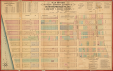
![[Upper East Side - Manhattan -- 79th Street to 93rd Street] Map of the Common Lands from 76th to 93rd Street Showing the Old Streets and Plots As Surveyed and Mapped in 1796, By Cassimer T. H. Goerck, City Surveyor and Resurveyed by Isaac T. Ludlam in 1822 (See Notes) And the Distance between those old Streets and our Present Streets Part 4](https://storage.googleapis.com/raremaps/img/small/61033.jpg)