This item has been sold, but you can enter your email address to be notified if another example becomes available.


|
||

|

|
|

|
Stock# 69569
Description
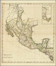
Scarce map of the United States, showing a massive Texas, published in London in 1848.
Texas is shown 2 years prior to statehood, with a massive oversized northwestern extension into New Mexico Territory.
Further north, the map includes an oversized Nebraska Territory, Dakota Territory and Wisconsin Territory.
This is the post-annexation Texas / pre-statehood configuration we have seen.
![[ Rotary Club International ] USCB Districts of Rotary International as of 1 July, 1958](https://storage.googleapis.com/raremaps/img/small/90418.jpg)
![[ Missouri named State of Jefferson ] Etats-Unis par A.M. Perrot](https://storage.googleapis.com/raremaps/img/small/99019.jpg)