This item has been sold, but you can enter your email address to be notified if another example becomes available.


|
||

|

|
|

|
Stock# 69558
Description
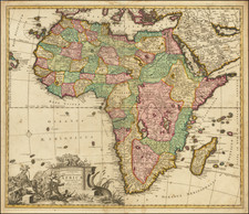
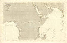
Fine large map of Africa, published by German mapmaker Heinrich Kiepert in Weimar.
The map is colored to illustrate the various local and colonial powers (Britain, Spain, Netherlands, France and Portugal).
The color coding also locate the possessions of the Ottoman Empire, possessions of the Imam of Muscat and the "northern border of the negro people."
Many early trade routes are located, with a massive void in Central Africa.
Condition Description
Minor toning at centerfold.
![[Africa - Anti-Colonialism]](https://storage.googleapis.com/raremaps/img/small/66876.jpg)