


|
||

|

|
|

|
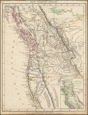
Early Map of Oregon Territory
Rare map of Oregon Territory, showing an accurate border location between Oregon Territory and British Columbia, published by Morse & Breese in the first part of the Cerographic Atlas of the United States.
The map is one of the earliest separate maps of Oregon Territory to appear in a commercial atlas, preceded only by Greenleaf's map. The map includes Indian Tribes, forts, towns, rivers, lakes, mountains and a host of other early details.
The map is very rare, as it was included only in "Part 1" of the atlas, issued in plain paper wraps, but was not included in the bound version of the atlas. Morse & Breese's North American Atlas was a landmark in American Cartography, being the first atlas to employ the cerographic printing process, which would revolutionize the map trade. The Morse family and this process are the subject of David Woodward's The All American Map. The maps were first printed in a series of inserts which appeared in the New York Post, and then later as a separate atlas.
An essential map for American Map collectors, illustrating an important change in the history of printed maps and the only truly American cartographic publishing innovation.
![[Montana, Wyoming, Dakota, Upper Missouri River] Amer. Sep. No. 40. Partie des Etats Unis](https://storage.googleapis.com/raremaps/img/small/93546.jpg)