


|
||

|

|
|

|
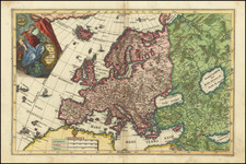
Interesting map of ten regions controlled by the Roman Empire, published for Benjamin Wills Newton.
The caption on the map notes:
The coloured part of this Map is intended to suggest the probable Territorial Arrangements That Will Be Found in the Roman Empire when finally divided into TEN Federal Kingdoms.
The map was likely a precursor to the publication of Newton's book, Prospects of the Ten Kingdoms of the Roman Empire considered: being the third series of aids to prophetic enquiry, published in 1873.
Benjamin Wills Newton (12 December 1807 – 26 June 1899) was an English evangelist, author of Christian books, and leader of a Plymouth church. His congregation and others around Plymouth became known as the Plymouth Brethren. Newton was a friend of John Nelson Darby, a well-known leader of the Plymouth Brethren, but the two men began to clash on matters of church doctrine and practice. This led to a 1848 split of the movement into the Open Brethren and Exclusive Brethren.
Rarity
The map is apparently quite rare on the market. We were unable to locate any examples at auction or in dealer catalogs.
OCLC locates 3 examples.
![(Czech Edition) Tabule zemj, fragin a mest/w nichz G. Paivael fazal [Bunting's Map of the Eastern Mediterranean Region]](https://storage.googleapis.com/raremaps/img/small/93467.jpg)
![[ Map of Modern Europe in Faces ] Карта современной Европы въ лицаx](https://storage.googleapis.com/raremaps/img/small/98887.jpg)
![[The First Maps Printed Color] Cartes en Couleur des Lieux Sujets aux tremblements de Terre Dans toutes les parties du Monde Selon le Sisteme de l’impulsion Solaire](https://storage.googleapis.com/raremaps/img/small/52293op.jpg)

![Chart of the Mediterranean Sea [Cyprus]](https://storage.googleapis.com/raremaps/img/small/72759.jpg)