|
||

|

|
|

|
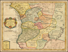
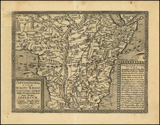
The Most Important Map of West Africa Published in the Sixteenth Century
Fine example of Pigafetta's map of West Africa, published in Rome in 1591 and engraved by Natale Bonifacio.
Pigafetta's map of Africa is based on the explorations of Duarte Lopes, a Portuguese whose voyages to the Congo Basin added to the speculation about the source of the Nile. The map depicts the portion of the Congo region visited by Duarte Lopes between 1578 and 1584, during his travels in Africa.
The reader is struck by the accuracy of the coastal outline, as well as by the density of place names and geographic features filling the interior. While not all have a basis in strict fact, this was the most detailed and certainly, for the Congo, the most precise map of Africa ever published to that time. The geography is dominated by large mountain ranges and long rivers.
The engraving work is quite exceptional, showing a significant move forward from the Lafreri Style of maps which had predominated in Italy for most of the 16th century. The map is dedicated to Antonio Migliori, the Bishop of San Marco from 1586-1591, and includes the arms of the First King of the Congo, Pope Sixtus V and the arms of Migliori.
The map includes an elaborate dedicatory cartouche, with the French phrase Il n'est rose sans épine (There is no rose without thorns), the motto of the House of Pigafetta.
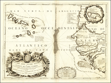
Significance of the Pigafetta map
Pigafetta published his two sheet map of Africa in 1591 to illustrate his account of the Lopes expedition to Africa. The Pigafetta map's significance lies in its revolutionary rejection of the Ptolemaic depiction of the interior Africa, one that was then still followed by cartographers, including the famous-atlas maker Ortelius. Pigafetta disputed the traditional Ptolemaic geography of twin lakes on the same latitude near the Mountains of the Moon as the source of the Nile River. Rather, Pigafetta shows two lakes in central Africa, one above the other. The southern one feeds the Zambezi and the Limpopo. The northern lake feeds the Nile and the Zaire. The northern lake is at and north of the equator, as opposed to farther south as Ptolemy placed his lakes. Following Waldseemuller, Pigafetta places a third, smaller lake to the west which is the source of the Congo River.
Pigafetta incorporated a number of other features in the interior of Africa which appear to derive from authentic indigenous sources. His series of works are without a doubt the most important maps of Africa published in the 16th century.
Although not all mapmakers adopted his non-Ptolemaic hydrography, others used him as an influential source for place names and geography of the Congo region. However, the Lopes-Pigafetta lake system was not widely adopted, making this map all the rarer and more significant for its originality, boldness, and relative accuracy.
The voyages of Duarte Lopes and the publication of Pigafetta's Relatione
Duarte Lopes was a Portuguese trader who traveled within central Africa, in what is now the Democratic Republic of the Congo and Angola, starting in 1578. After several successful merchant voyages, Lopes was appointed as ambassador for Congo's king, Alvaro II, to Spain (which was then unified with Portugal). Lopes replaced Sebastian da Costa, who had died on his return trip to report to Philip II of Spain.
While ambassador, Lopes sought out mineral specimens to share with his European contacts in the hope they would yield gold, silver, or another precious metal. He also opened the region to trade with Portugal and Spain, a major advantage for the vast Spanish Empire. Finally, Lopes vowed to lobby the Pope to send missionaries to Central Africa.
On his return trip from Congo, Lopes was shipwrecked on the coast of Venezuela. After a year marooned there, he returned to Europe to continue to fight for his causes, although the calls went unheeded. He returned to Congo in 1589 and was never heard from again.
Before he disappeared, however, Lopes told Filippo Pigafetta (ca. 1533-1604) the story of his travels and gave him a single manuscript map. Pigafetta was a historian who traveled extensively. He also served as a Chamberlain to Pope Sextus, a position that would give him access to information and a certain measure of power in Roman society.
Pigafetta published the narrative of Lopes' adventures, Relatione del realme di Congo et delle circonvicine contrade, in 1591. The book also included this map as a copperplate engraving, the best of Africa to date, and another, larger scale map of the Congo. It appeared first in Italian (Rome, Bartolomeo Grassi, 1591).
The work was quickly translated into other European languages: Dutch (trans. Martin Everart, Bruges, Amsterdam, 1596), German (trans. Augustine Cassiadore Reinius, published by De Bry, Frankfurt 1597), and Latin (De Bry, Frankfurt, 1598). The translations often included the maps. For example, the German edition, part of the De Bry brothers' Petit Voyages, includes versions of the two maps which are similar to the originals, although not as ornate.
Abraham Hartwell, at the request of travel compiler Richard Hakluyt, translated the work into English, and it was published in London in 1597, with maps included. Samuel Purchas included the tale in his Pilgrimes (London, 1625) and it is widely accepted that Daniel Defoe used the narrative while writing The adventures of Captain Singleton (London, 1720).
Rarity
The original Pigafetta map is exceedingly rare on the market. This is the first example we have ever offered for sale.
Raymond John Howgego, ed., “Lopez, Duartem” in Encyclopedia of Exploration to 1800 (Hordern House, 2003), 646.
Francesc Relano, The Shaping of Africa: Cosmographic Discourse and Cartographic Science in Late Medieval and Early Modern Europe (Ashgate, 2002), ch. 12.
Francesc Relano, “Against Ptolemy: The Significance of the Lopes-Pigafetta Map of Africa,” Imago Mundi 47 (1995): 49-66.
Jeffrey C. Stone, ed., Norwich’s Maps of Africa: An Illustrated and Annotated Carto-Bibliography, 2nd edition (Terra Nova Press, 1997), map 16.
Internal Notes
![[Africa] Prima Tavola](https://storage.googleapis.com/raremaps/img/small/96586.jpg)