|
||

|

|
|

|
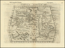
Rare English Edition -- Stunning Map of Eastern Africa
Striking example of the rare English Edition of Linschoten's map of Eastern Africa, which appeared in the rare English edition of Linschoten's Itinerario, Iohn Huighen van Linschoten. His discours of voyages . . . , published in London in 1598, and engraved by English engraver "R.E." (Raygnald Elstrak).
The map is filled with cartographic an iconographic details, including sailing ships and sea battles, sea monsters, animals within Africa, numerous compass roses and strap-work cartouche. The map shows the eastern side of Africa and part of the Indian Ocean (the bottom parts of present-day India and Ceylon appear in the upper right corner). The western Nile source lake of Zaflan is shown. Above this lake is a visual representation of the Kingdom of Prester John in Ethiopia. The cartouche on the right side contains the titles in Latin and in Dutch with a description of the territories which translates to English as follows: "Illustration of the coasts of the land called Terra do Natal, and likewise of all the coasts of Safala, Mozambique, Melinde, and the island of S. Lorenzo [Madagascar] ... likewise of the islands from Maldiva to the Island of Ceylon shown to the promontory of Cormorin, situated on the coast of India ... all very accurate, revised, and improved in accordance with the very best Indian maps."
The extensive details of coastal and other navigational points are likely based on portolan charts of the Portuguese, especially those by Bartolomeu Lasso. Linschoten was "one of the pathfinders for the first Dutch voyages to the East" (Schilder, p. 195). He was in the service of the Portuguese as Secretary to the Portuguese Archbishop of Goa in India from 1583 to 1589. Here, he had access to many Portuguese portolans as well as other valuable commercial information, especially as Goa at this time was the commercial and political center for the Portugal Empire in the East. Van Linschoten left Goa for home in January 1589. On the way to Portugal, his ship was pursued by an English fleet and lost its cargo in a storm while anchored off the Azores. After the loss of the cargo, Van Linschoten was persuaded to stay and help recover it; he spent two years on Tercera, working and preparing his notes from Goa.
Van Linschoten eventually arrived in Lisbon early in 1592, and then sailed home to The Netherlands. His account of his experiences is one of the most important travel works of the period.
Wolfe, Linschoten, and the Itinerario
In 1594, Linschoten set out with Willem Barentsz on an exploratory expedition to find the Northeast Passage. The crew had many adventures, including an encounter with a polar bear, which they killed while attempting to capture it. Eventually, the crews had to turn back because of ice, a situation that also happened with a similar expedition the following year.
Upon his return, Linschoten published his journal from the Barenstz voyages. In 1595, he also published Reysgheschrift vande navigation der Portugaloysers in Orienten (Travel Accounts of Portuguese Navigation in the Orient), based on his research. The work includes sailing directions in addition to descriptions of lands still new to Europeans, like Japan. In 1597, Linschoten published again, this time a description of the African coast.
His most famous work, however, is Itinerario: Voyage ofte schipvaert van Jan Huyghen van Linschoten naer Oost ofte Portugaels Indien, 1579-1592 (Travel account of the voyage of the sailor Jan Huyghen van Linschoten to the Portuguese East India). It was published in 1596 by Cornelis Claesz in Amsterdam.
Two years later, in 1598, John Wolfe published an English translation, with entirely newly maps engraved in London by Robert Beckit, Raygnald Elstrak, William Rogers. The 11 maps includes several maps not drawn from the original Lisnchoten Itinerario, including a World Map after Ortelius, two maps of Africa drawn from Pigafetta, and an English copy of the first state of the Plancius Spice map.
Rarity
The Wolfe edition of Linschoten's work is very rare on the market, as are the individual maps.
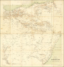
![(Horn of Africa) Abessinien Somaliländern [cover title:] Neue Karte von Abessinien und Somaliländern](https://storage.googleapis.com/raremaps/img/small/97482.jpg)