|
||

|

|
|

|
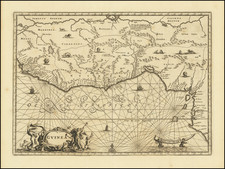
Rare English Edition -- Sixteenth-Century Decorative Map of South and West Africa from Linschoten's Influential Itinerario
Striking map of South Africa, West Africa and contiguous parts of the Atlantic.
This is one of the most richly ornamented maps of the era, which appeared in the rare English edition of Linschoten's Itinerario, Iohn Huighen van Linschoten. His discours of voyages . . . , published in London in 1598, and engraved by English engraver "R.E." (Raygnald Elstrak).
One of the great Africa maps of the sixteenth century, the map shows the coast of Africa from Guinea to South Africa. The coast is drawn in fine detail from the Gulf of Guinea to just beyond the Cape of Good Hope.
Animals and other creatures dot the interior. A lion stares intently, watching a pair of snakes to the northwest. An elephant and a rhino face off farther south. In Lake Zaire ( Zaire lacus), two mermaids play musical instruments. At sea, two ships are in full sail, pursued by a sea monster and an even larger rival ship. These additions underline how Europeans saw Africa as a place of possible trade and exotic flora and fauna.
In an elaborate scrollwork cartouche in the Atlantic are two beautiful, large inset profile views. On the left is Ascension, with its strange peaks. A ship is already at anchor with more on the horizon. On the right is St. Helena, where a small boat filled with men approach the tree-lined landing spot. These were important refueling stations, again stressing the importance of Africa in trade routes to the East.
The balance of the sheet is filled with fabulous cartouches, the Portuguese arms, elaborate compass roses, ships, and beasts. These details make this perhaps the most spectacular map of the region published in the sixteenth century and it is in wonderful condition.
Monomotapa
In the interior, the fictitious cities of Vigiti Magna and Monomotapa are located and most place names and geographical features have Portuguese nomenclature. Take Monomotapa as an example. In the early fifteenth century, a prince of the Kingdom of Zimbabwe established his own seat of power called the Kingdom of Mutapa to the north. The kingdom expanded quickly, fed by the region's gold reserves and trade connectivity.
The Portuguese heard of the empire, which reached its peak in 1480, when they rounded the Horn at the end of the fifteenth century and began trading along the coasts of southern Africa. The Portuguese traders transliterated the word for ruler, Mwenemutapa, to Monomotapa, which was then used to describe the region on maps.
In the 1560s, the Portuguese Crown entered into direct relations with Mutapa; in 1569, King Sebastian gave a coat arms to the Mwenemutapa, the first grant of arms to a native southern African. However, this interaction was not characteristic of Portuguese-Mutapa relations, which were often combative as the Portuguese sought to take over the local gold reserves. These gold reserves were connected in European minds to the gold mines of King Solomon, ensuring Monomotapa an enduring place in the European geographic imagination.
Wolfe, Linschoten, and the Itinerario
In 1594, Linschoten set out with Willem Barentsz on an exploratory expedition to find the Northeast Passage. The crew had many adventures, including an encounter with a polar bear, which they killed while attempting to capture it. Eventually, the crews had to turn back because of ice, a situation that also happened with a similar expedition the following year.
Upon his return, Linschoten published his journal from the Barenstz voyages. In 1595, he also published Reysgheschrift vande navigation der Portugaloysers in Orienten (Travel Accounts of Portuguese Navigation in the Orient), based on his research. The work includes sailing directions in addition to descriptions of lands still new to Europeans, like Japan. In 1597, Linschoten published again, this time a description of the African coast.
His most famous work, however, is Itinerario: Voyage ofte schipvaert van Jan Huyghen van Linschoten naer Oost ofte Portugaels Indien, 1579-1592 (Travel account of the voyage of the sailor Jan Huyghen van Linschoten to the Portuguese East India). It was published in 1596 by Cornelis Claesz in Amsterdam.
Two years later, in 1598, John Wolfe published an English translation, with entirely newly maps engraved in London by Robert Beckit, Raygnald Elstrak, William Rogers. The 11 maps include several maps not drawn from the original Lisnchoten Itinerario, including a World Map after Ortelius, two maps of Africa drawn from Pigafetta, and an English copy of the first state of the Plancius Spice map.
Rarity
The Wolfe edition of Linschoten's work is very rare on the market, as are the individual maps.