|
||

|

|
|

|
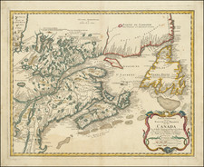
Nice three-stone color-lithographed bird's-eye view of New England, with an inset view of New York and Manhattan at the bottom edge. The specific focus of the map is the so-called Fall River Line, which was a very popular method of traveling between New York and Boston during the end of the 19th century and beginning of the 20th.
The map shows rail and steamer connections within New England and to New York City. On either side are timetables for the Summer of 1887.
The Fall River Line was a combination steamboat and railroad connection between New York City and Boston that operated between 1847 and 1937. It consisted of a railroad journey between Boston and Fall River, Massachusetts, where passengers would then board steamboats for the journey through Narragansett Bay and Long Island Sound to the line's own Hudson River dock in Manhattan. For many years, it was the preferred route to take for travel between the two major cities. The line was extremely popular, and its steamboats were some of the most advanced and luxurious of their day.
![Rand, McNally & Co's Map of the Main Portion of Brooklyn [on verso] Map of the Southern Portion of New York City](https://storage.googleapis.com/raremaps/img/small/86750.jpg)
![[Portland & Cape Elizabeth to Moskito Island -- Centered on Kennebec River]](https://storage.googleapis.com/raremaps/img/small/50079.jpg)