|
||

|

|
|

|
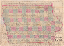
Illustrating The Black Hawk Purchase As The Settled Part of Iowa Territory
Rare early map of the surveyed portions of Iowa, corresponding to the lands acquired by the United States as part of the Black Hawk Purchase, from an early example of Morse's Cerographic Atlas of the United States.
During the mid-19th century, a critical shift in the geopolitical landscape of the United States occurred, marking a turning point in the nation's relentless push towards the West. This period bore witness to the formation of the Iowa Territory, a vast tract of wilderness that would eventually develop into one of the most prolific agricultural states in the country.
Iowa Territory came into existence on July 4, 1838, carved out of Wisconsin Territory. This seminal event happened after the series of treaties with Native American tribes such as the Sauk and Meskwaki, most notably the Black Hawk Purchase, which opened up large tracts of land to white settlement. The boundaries of this nascent territory included parts of Minnesota and North Dakota, alongside the present-day state of Iowa.
The Black Hawk Purchase, also known as the 1832 Treaty of Fort Armstrong, played a critical role in the settlement and development of Iowa. This agreement between the United States and the Sac and Fox Indians followed the Black Hawk War, a brief conflict in 1832. Under the Treaty, the Native American tribes ceded about six million acres of their land on the Mississippi River's west bank to the United States. This land is a significant part of present-day Iowa and was acquired by the U.S. government to open up for settlement.
In the immediate aftermath of the Black Hawk Purchase, the U.S. government initiated a land survey and established land offices to manage the sale of the land to settlers. The availability of this fertile and relatively inexpensive land stimulated migration to the region. In the years following the purchase, significant settlements like Dubuque, founded in 1833, and Davenport, established in 1836, began to develop along the Mississippi River. The influx of settlers grew steadily throughout the 1830s and 1840s, leading to the formal establishment of the Iowa Territory in 1838.
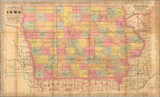
One of the earliest counties, Dubuque County, was created in 1834, before the formal establishment of the Iowa Territory. The county was named after Julien Dubuque, a French-Canadian fur trader and lead miner, who was among the first white men to settle in the region. The city of Dubuque, situated on the bank of the Mississippi River, served as a strategic location for commerce and industry.
Similarly, Des Moines County, established in 1834, was one of the first counties and a vital location for early settlers. Its county seat, Burlington, served as the capital of the Iowa Territory from 1838 until 1841. Another notable settlement was the city of Iowa City, founded in 1839, which took over as the territorial capital in 1841 and held this honor until Des Moines became the capital in 1857.
Throughout this period, the Iowa Territory underwent rapid development, shaped by the ever-growing influx of settlers. Between 1838 and 1846, the population of the territory exploded from around 22,859 to over 100,000, triggering the creation of numerous new counties and settlements, such as Lee, Henry, and Scott Counties. On December 28, 1846, the tireless efforts of these early settlers were rewarded when Iowa was admitted as the 29th state of the Union.
Morse & Breese's North American Atlas was a landmark in American Cartography, being the first atlas to employ the cerographic printing process, which would revolutionize the map trade. The Morse family and this process are the subject of David Woodward's The All American Map. The maps were first printed in a series of inserts which appeared in the New York Post, and then later as a separate atlas.

![[Montana, Wyoming, Colorado, Dakotas, etc] Reconnaissances in the Dacota Country By G.K. Warren](https://storage.googleapis.com/raremaps/img/small/82655.jpg)