


|
||

|

|
|

|
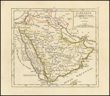
One of the earliest printed maps of Saudi Arabia to include the name Arabian American Oil Company (Aramco)
Highly detailed map of Saudi Arabia, published by the Arabian American Oil Company in August 1951 and Revised in 1953.
The map is one of the earliest maps to name the Arabian American Oil Company, which was not formally re-named until 1944 (sources differ, but this date is the most reliable).
Riyadh is shown with what appears to be a rail line running east through Haradh, Uthmaniyah, and Abqaiq to the sea at Qatif, with a second rail line extending to Fadhili.
The map presents a detailed look at the region which was then just beginning developed by Aramco. The Trans-Arabian Pipeline is shown, as is the Aramco Pipeline, with a Neutral 1/2 Zone just to the north of Ain Uquba and Hafar Al-Batin.
In the eastern part of the Peninsula, there are a number of trails and roads to the northwest of Qatar.
In Qatar, Hawar Well is shown, as is Doha.
On the Trucial Coast, Abu Dhabi, Dubai, and Sharjah are shown, with an airstrip between Dubai and Sharjah. To the east, the Sultanate of Muscat and Imamate of Oman are named.
The map cautions:
Geographic positions shown on this map are based on best information at time of compilation. Much is based only on brief traveller's accounts. Map is therefore subject to revision.
Rarity
The map is very rare. OCLC locates 1 example (Harvard University).
![[ Black & Caspian Sea Region ]. Tabula Asiae III [](https://storage.googleapis.com/raremaps/img/small/76322.jpg)
![A New Map of the Eastern Parts of Asia Minor Largely taken as Also of Syria, Armenia, Mesopotamia &c . . .Dedicated to his Highness William Duke of Glocester [shows Cyprus]](https://storage.googleapis.com/raremaps/img/small/90579.jpg)