This item has been sold, but you can enter your email address to be notified if another example becomes available.


|
||

|

|
|

|
Stock# 69339
Description
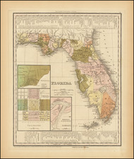
Detailed working sea chart of Miami Harbor, published by the US Coast & Geodetic Survey.
Includes a nice early town plan of Miami, and early details on Virgin Key, Key Biscayne and South Miami Beach.
The map extends north to Bal Harbor and South to Chicken Key and Key Biscayne.
Condition Description
Minor Soiling
![[Florida & Bahamas] Amer. Sep. No. 62. Florides et Iles Lucayes](https://storage.googleapis.com/raremaps/img/small/101496.jpg)

![[Florida to New Orleans] The North Coast of the Gulf of Mexico from St. Marks to Galveston . . . 1842](https://storage.googleapis.com/raremaps/img/small/83469.jpg)