|
||

|

|
|

|
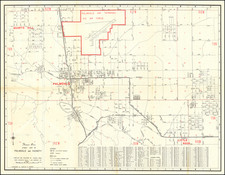
If Only Los Angeles Traffic Moved This Fast!
A great little map of Los Angeles from the early 1920s depicting the speed limit zones in Los Angeles proper. The map was issued by the map service of the Automobile Club of Southern California, text on the verso indicates that the map was issued in 1922 or 1923.
The front of the map shows Downtown LA with two speed limit zones: 20 miles per hour in the less dense areas, and 15 miles per hour in the most built-up zones.
On the back of the map are diagrams and helpful reminders for drivers. One of the diagrams shows the required distance to stop when traveling at certain speeds (from 10 to 50 miles per hour), the other diagram shows the hand signals to use for turning or slowing down (before turn signals and brake lights were ubiquitous).
![[ California Petroleum ] A Description of the Recently Discovered Petroleum Region in California. With a Report on the Same [with:] Map Representing Locality of The Ojai Ranch in Santa Barbara County, California, belonging to the California Petroleum Company 1865](https://storage.googleapis.com/raremaps/img/small/103844.jpg)