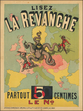
|
||

|

|
|

|
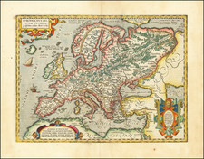
A French View of Europe Immediately After the Napoleonic Wars.
Beautiful and exactingly-engraved four-sheet map of Europe, published in Paris in 1816 by France's foremost mapmaker of the time, Hubert Brué.
The map is noteworthy for its precision of detail and treatment of the byzantine political boundaries that followed the resolution of the Napoleonic Wars and the restoration of the Bourbon Monarchy. No place are the borders more convoluted than in Germany. For this the map devotes an entire key in the lower-left corner titled "States of Germany".
The map comes from a set of four-sheet maps that Brué made for this Atlas Universel Encyprotype which featured a series of four-sheet maps and single sheet reductions.
The map is rare, this being the first time we have had it.
Andre Hubert Brué was a French geographer and cartographer. Born in Paris, he served in the French Navy, joining the Baudin expedition to the Pacific (1800-1804). After his sea service, Brué applied his navigation and charting skills to creating finely-crafted maps, which were renowned for their crisp engraving and accuracy. He drew directly on the copper of the plate, creating what he called encyprotypes. He is best known for the Atlas universal de géographie physique, politique, ancienne et moderne.
![[ Roman Empire ] Map of the Roman Empire At the period of its greatest extent - engraved to illustrate Mitchell's Ancient Georgraphy](https://storage.googleapis.com/raremaps/img/small/101112.jpg)
![(First World War - Seriocomic) Европа въ 1915 г. [Europe in 1915]](https://storage.googleapis.com/raremaps/img/small/98679.jpg)