|
||

|

|
|

|
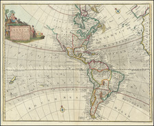
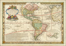
Finely detailed map of America on the eve of the 19th Century and the radical transformation that would see the European powers expelled from both North and South America.
The table in the bottom left corner showing the various British, French, Spanish, Dutch, Danish, and Portuguese possessions completely re-written over the next 75 years. Spain still dominates the American West, including the massive Louisiana Territory.
The Northwest Coast of America is based upon the explorations along the Northwest Coast by Cook, La Perouse, etc., however the radical changes brought about by Lewis & Clark 10 years later are not yet in evidence and the course of the Upper Missouri is still largely unknown, terminating west of the Otter Nation, with no sign of the Rocky Mountains. Further north, several Hudson Bay Trading Company Houses are shown in central Canada, but the west is largely empty.
The Oregon River or River of the West popularized in the mid 18th Century by Jonathan Carver is still shown. Curious shape for Baja California. The Alaskan Archipelago is well formed, but the Northwest Passage and Arctic Coastline above Canada are still largely speculative, with a band of ice stretching across the northern sea above the Behring Strait described as "Impenetrable Ice," a choice of words derived from Captain Cook's observations in August 1778.
The Bowles & Carver Universal Atlas is one of the rarer larger format late 18th Century English Atlases. While earlier imprints by Carrington Bowles appear on the market on occasion, this late edition is very unusual.
![[ Prague Travel Agency Poster ] 1tes Prager Conces Reise-Bureau D. Schick & Rosenbaum Prag. Spedition: Wenzelsplatz No. 15 (Round-Trip Tickets & Ship Tickets to all of America . . . )](https://storage.googleapis.com/raremaps/img/small/96465.jpg)