


|
||

|

|
|

|
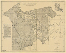
Plantations on the Mississippi River -- District North of Red River
Hand drawn survey map of a section of the Mississippi River, which highlights "Ion's Plantation" and the area immediately down river from New Carthage, covering what would become the Ion Plantation, Perkins (Somerset) Plantation and Ashwood Plantation by the start of the Civil War.
The present map likely shows a part of the acquisition process by which Judge John Perkins Sr. amassed the land which would become known as the Sommerset Plantation, approximately 15 miles south of Vicksburg, Mississippi, on a section of land that appears to be contiguous to the Davis Island area.
Fascinatingly, the area of the Mississippi River no longer in existence, or, more accurately, no longer contiguous to the Mississippi River. The area was part of the region which was levied and modified by nature and the Bureau of Topographical Engineers over time. The Ion Plantation and the area can be plainly seen on Lloyd's Map of the Lower Mississippi River: https://www.raremaps.com/gallery/detail/46623
The area shown includes the plantation of John Perkins and the Ion Plantation, in Madison Parish, Louisiana. Ion's Plantation is noted in several Civil War era reports as being just down river from New Carthage and next to the large planation owned by John Perkins. The present map shows surveyed tracts of land along the Mississippi River, one area labeled "ion's Plantation" in purple, with a central "Table of Contents" listing each land section and total area, list of "Claimant's Names" beneath, inscribed at right.
The map identifies 3 "claimants"
- Joe Lobdell
- A. McCormack
- John Perkins
Other land owners named and place names on the map include:
- Richmond Knight
- Bledsoe? & John
- "Between, Burke & Knight"
- Hughes & Herring
- A Herring
- Vidal Lake
A note at the bottom right of the map states:
The whole of this Township was Surveyed by Phail A. Currier, Deputy Surveyors in January 1829. Surveyors Office Wash. Miss. May 4th 1829.
Examined Approved
(signed) James P. Turner Surveyor of Public Land South Tenessee (sic)
A True Copy Test (signed) Edmund Filhiol
John Perkins
John Perkins is almost certainly John Perkins Sr., an American judge and planter, who would was the owner of a plantation in Vidalia, Louisiana, from 1807 to 1811. He eventually became the owner of "Somerset", an 18,000-acre estate in Madison Parish and Tensas Parish. In 1815, Judge Perkins began the purchase of contiguous tracts of land in the northern part of what is now Tensas Parish, but at that time in Concordia. These tracts bordered the Mississippi River, and they were known as the Homestead, Via Mede, Back Land, and Wildwood plantations, all lying south of Bayou Vidal, and the Hapaka plantation which lay to the north of the bayou. These plantations all adjoined, and Judge Perkins consolidated them into one vast property of seventeen thousand five hundred acres, to which he gave the name "Somerset Estate," in commemoration of his boyhood home in Maryland. Some of these tracts were acquired as late as 1840. A deed of 1820 recites that the lands purchased "adjoin the Somerset establishment of John Perkins at the mounts"--Indian mounds (likely Balmoral Ancient Native American Mounds).
Rarity
The map is apparently a unique survival.
Provenance: Brunk Auctions, July 31, 2020
![[Louisiana / British Emigration -- 5 Maps] Land District North of the Red River in the State of Louisiana / District North of the Red River Louisiana / Land District North of the Red River, State of Louisiana / Township 20 N. Range 13 East, Land District North of the Red River in the State of Louisiana / A Map, exhibiting the order oft he Surveys of the Public Lands of the United States of North America . . . .](https://storage.googleapis.com/raremaps/img/small/90084.jpg)