|
||

|

|
|

|
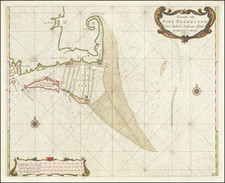
Nice example of Seutter's map of New England, including a fine early view of New York City.
Matthaus Seutter's edition of one of the most decorative maps of the region produced during the 17th and 18th Centuries. The genesis of this map was studied in great detail by Tony Campbell in an article entitled The Jansson-Visscher Maps of New England, which appears as Chapter 8 of Tooley's Mapping of America.
The map is based upon Jan Jansson's map of 1651. Seutter replaces the Restitutio view of New York City with a new view of New York entitled Neu Jorck sive Neu Amsterdam, with a key to the view in Latin.
Above the view is an elaborate scene depicting natives and gods presenting tribute to the English monarch George II. The course of the Delaware and Hudson are separated, unlike early editions of the map. This is the first map in the series to show the boundaries of Massachusetts, New England, New York, New Jersey, and Pennsylvania with a printed lines, as earlier examples had previously left the delineation of the boundaries to the colorist. Philadelphia is shown as a set of houses in relief, rather than a ground plan.
This is the fourth state of the map. The state can be identified as follows:
- First State: Matthias Seutter listed as mapmaker. "Chalcographi Augustani" is shown as the place of publication.
- Second State: Place of publication is changed to "Sac. Caes. Maj. Geographi August. Vindi."
- Third State: Extra line under the place of publication states: "Cum Gratia et Privil. S.R. I. Vicariat, in part, Rheni, Sueviae, et Juris Franconici."
- Fourth State: Tob. Conr. Lotteri (Lotter) is listed as the mapmaker. The town of "Briston" (Boston) is added.
- Fifth State: Briston is corrected to Boston.
- Sixth State: "S.A.L.A." is added after "August Vindi" in the imprint.
Matthäus Seutter (1678-1757) was a prominent German mapmaker in the mid-eighteenth century. Initially apprenticed to a brewer, he trained as an engraver under Johann Baptist Homann in Nuremburg before setting up shop in his native Augsburg. In 1727 he was granted the title Imperial Geographer. His most famous work is Atlas Novus Sive Tabulae Geographicae, published in two volumes ca. 1730, although the majority of his maps are based on earlier work by other cartographers like the Homanns, Delisles, and de Fer.
Alternative spellings: Matthias Seutter, Mathaus Seutter, Matthaeus Seutter, Mattheus Seutter