|
||

|

|
|

|
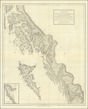
Finely executed British Admiralty Sea Chart, illustrating Victoria, British Columbia and environs.
The chart shows a well developed waterfront around James Bay and the Harbor, with an outline of the streets shown in great detail in interior. At the southeast corner, Beacon Hill and the Rifle Range are shown south of the Public Park. North of the city, the Upper Harbor and Portage Inlet are shown, along with roads and railways.
Near the waterfront, many wharves, piers, warehouses and maritime facilities are shown along with private industry.
Victoria, BC
In 1841, James Douglas was tasked with setting up a trading post on the southern tip of Vancouver Island, upon the recommendation by George Simpson, in case Fort Vancouver to the south was lost to the Americans. Douglas founded Fort Victoria on the site of present-day Victoria.
Erected in 1843 as a Hudson's Bay Company trading post and briefly known as "Fort Albert", the settlement was renamed Fort Victoria in November 1843. Between the years 1850-1854 a series of treaty agreements known as the Douglas Treaties were made with indigenous communities to purchase certain plots of land in exchange for goods. These agreements contributed to a town being laid out on the site and made the capital of the Vancouver Island Colony (formed in 1849).
When news of the discovery of gold on the British Columbia mainland reached San Francisco in 1858, Victoria became the port, supply base, and outfitting center for miners on their way to the Fraser Canyon gold fields, mushrooming from a population of 300 to over 5000 within a few days. Victoria was incorporated as a city in 1862. In 1865, the North Pacific home of the Royal Navy was established in Esquimalt and today is Canada's Pacific coast naval base. In 1866 when the island was politically united with the mainland, Victoria was designated the capital and became the provincial capital when British Columbia joined the Canadian Confederation in 1871.
In the latter half of the 19th century, the Port of Victoria became one of North America's largest importers of opium, serving the opium trade from Hong Kong and distribution into North America. Opium trade was legal and unregulated until 1865, when the legislature issued licenses and levied duties on its import and sale. The opium trade was banned in 1908. In 1886, with the completion of the Canadian Pacific Railway terminus on Burrard Inlet, Victoria's position as the commercial center of British Columbia was irrevocably lost to the city of Vancouver, British Columbia.
The British Admiralty has produced nautical charts since 1795 under the auspices of the United Kingdom Hydrographic Office (HO). Its main task was to provide the Royal Navy with navigational products and service, but since 1821 it has also sold charts to the public.
In 1795, King George III appointed Alexander Dalrymple, a pedantic geographer, to consolidate, catalogue, and improve the Royal Navy’s charts. He produced the first chart as the Hydrographer to the Admiralty in 1802. Dalrymple, known for his sticky personality, served until his death in 1808, when he was succeeded by Captain Thomas Hurd. The HO has been run by naval officers ever since.
Hurd professionalized the office and increased its efficiency. He was succeeded by the Arctic explorer Captain William Parry in 1823. By 1825, the HO was offering over seven hundred charts and views for sale. Under Parry, the HO also began to participate in exploratory expeditions. The first was a joint French-Spanish-British trip to the South Atlantic, a voyage organized in part by the Royal Society of London.
In 1829, Rear-Admiral Sir Francis Beaufort was appointed Hydrographer Royal. Under his management, the HO introduced the wind force scale named for him, as well as began issuing official tide tables (1833). It was under Beaufort that HMS Beagle completed several surveying missions, including its most famous voyage commanded by Captain FitzRoy with Charles Darwin onboard. When Beaufort retired in 1855, the HO had nearly two thousand charts in its catalog.
Later in the nineteenth century, the HO supported the Challenger expedition, which is credited with helping to found the discipline of oceanography. The HO participated in the International Meridian Conference which decided on the Greenwich Meridian as the Prime Meridian. Regulation and standardization of oceanic and navigational measures continued into the twentieth century, with the HO participating at the first International Hydrographic Organization meeting in 1921.
During World War II, the HO chart making facility moved to Taunton, the first purpose-built building it ever inhabited. In 1953, the first purpose-built survey ship went to sea, the HMS Vidal. Today, there is an entire class of survey vessels that make up the Royal Navy’s Hydrographic Squadron. The HO began to computerize their charts in the late 1960s and early 1970s. In 1968, the compilation staff also came to Taunton, and the HO continues to work from there today.
![[ Pacific Northwest - Northwest Passage ] Limes Occidentis Quivira et Anian. 1597](https://storage.googleapis.com/raremaps/img/small/71207.jpg)