


|
||

|

|
|

|
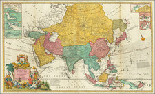
Scarce carte-a-figure map of Asia, by Frederick de Wit, published in Amsterdam in 1660.
The map features extensive decorative illustrations in the borders, including at the top, the towns of "Ormus", Aden, Jerusalem, "Damasco", "Rodus", and "Famgusta" after Braun & Hogenberg.
The panes at the sides show de Wit's interpretations of the traditional garb of the peoples of Asia, labeling them as: "Tartarus", "Chynaica Mulier [woman]", "Arabis", "Mulier Javanica", "Mulier Tartarica", "Chynensis", "Arabic Mulier", and "Javensis".
Another example made 4,000 GBP at Sotheby's in 2010.
This is the first time we have had the map.
De Wit (1629 ca.-1706) was a mapmaker and mapseller who was born in Gouda but who worked and died in Amsterdam. He moved to the city in 1648, where he opened a printing operation under the name of The Three Crabs; later, he changed the name of his shop to The White Chart. From the 1660s onward, he published atlases with a variety of maps; he is best known for these atlases and his Dutch town maps. After Frederik’s death in 1706, his wife Maria ran the shop for four years before selling it. Their son, Franciscus, was a stockfish merchant and had no interest in the map shop. At the auction to liquidate the de Wit stock, most of the plates went to Pieter Mortier, whose firm eventually became Covens & Mortier, one of the biggest cartography houses of the eighteenth century.
![[ World & Continents ] Typus Orbis Terrarum / Americae Sive Novi Orbis Nova Descriptio / Asiae Nova Descriptio / Africae Tabula Nova / Europae](https://storage.googleapis.com/raremaps/img/small/99250.jpg)
![[ Ancient Asia ] Asia](https://storage.googleapis.com/raremaps/img/small/102082.jpg)
![[Rare Complete Example with Game Pieces] Grand Circuit Des Capitales. Collection Concours Du Chocolat Menier](https://storage.googleapis.com/raremaps/img/small/70922rd.jpg)