|
||

|

|
|

|
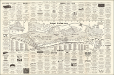
A great pictorial map of Malibu, the famed California beach community of the rich and famous. Taken from the south, the map shows the community in bright colors, with the ocean visible in the foreground. The map was produced through a model that asked for businesses to pay for their locations to be advertised on the map, and so the Ranlee pictorial maps became excellent snapshots of communities during the era. The map speaks to the 1980s and Malibu's culture during that decade.
In the lower right corner is a note elaborating the history of Malibu. It notes that the first residential lots in Malibu were sold in the 1920s.
The Ranlee Publishing Company ran a short-lived but very successful business based on producing maps of cities across the US, which were funded by charging advertisers several hundred dollars each for advertising space. While the company eventually grew to have branch offices in eleven cities across the nation, it would be dismantled in the late 1980s after charges of defrauding businesses who had paid for, but never received, maps.
Though Ranlee Publishing Company is mostly associated with New Jersey (whether Englewood Cliffs or Bloomfield), the phone number for the company on this map has a 714 area code, which covers part of Orange County, California.
Maps of Malibu of any variety are extremely rare on the market; in almost 30 years dealing in maps in Southern California, this is the first we've had.
![[Union City] Town of Decoto, Alameda Co. Cal. / Suburban Homes in the Orange Belt](https://storage.googleapis.com/raremaps/img/small/72845.jpg)