


|
||

|

|
|

|
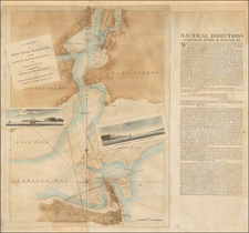
Detailed 2-sheet manuscript cadastral map of the Servis Grant, in Oneida County, to the east of Rome, New York.
The map is bounded on in the northeast by West Canada Creek and extends from about Hinkley Reservoir and Prospect in the north to the area around South Trenton.
The map would seem to be a cadastral map on which a number of transfers have been recorded over a period of decades.
History of the Servis Patent
The Servis Patent consisted of about 25,000 acres, mostly in Trenton, New York, granted February 28, 1769, to Peter Servis and twenty four others. The primary beneficiary of the Grant was Sir William Johnson. Peter Servis was a relative of the first wife of Sir William. The twenty four others were his tenants or hired retainers. Jones's Annals of Oneida County states that after the patent was issued Sir William made a great feast, roasted an ox, and when the patentees were "in a happy mood", procured an assignment of the patent to himself.
Reportedly, most of the larger grants were thereafter transferred to members of government or military officers. Before the death of Sir William in 1774 he had conveyed away about half of the patent, as recited in his will.
After his death, Johnson's executors, as provided by the will, sold the remainder (about 13,000 acres) but to whom cannot be ascertained. Reportedly, because of the Revolution, his title deeds were buried in the ground near Johnstown by his son, Sir John, and when recovered after the war were so moldy as to make the writing illegible. In a litigation concerning some of the lands, as it appeared, a deed or patent to Sir William was once in existence, and on proof of loss, the court allowed parole proof to be given of the deed or patent and the contents.
The records of Oneida county show that as early as 1793 John Kelly, of New York, owned 2,000 acres in the southwest corner of Servis Patent, next to Holland Patent, and partly in Trenton and partly in Marcy. It is called the "Kelly Tract", in the deeds and on the Oneida county maps. It was subdivided in 1793 into twenty two lots by William Cockburn, surveyor. The records do not show who conveyed to Kelly. In about 1790, Gerrett Boon and others owned the Servis Patent, excepting the Kelly Tract, and other lands for the Holland Land Company. The records do not show who conveyed to Boon and others. In 1798, Peter Kemble, father in law of General Thomas Gage, purchased the Kelly Tract from Kelly. In 1795 the remainder of the Servis Patent was divided into 191 lots by Calvin Guiteau, surveyor. Kelly died in 1801.
By March 1801, the lands had been conveyed to the Holland Land Company.
The Map
The map shows this large land grant to the east of Steuben Township in what is now Oneida County, New York. Most of the 191 lots have the land-owners identified, with many lots updated to the middle of the 19th century.
In the supplement to Part 3 his 1875 catalogue entitled Catalogue of Books Maps, Plates of America . . . at page 170, Frederick Muller (literary agent of the Smithsonian Institution of Washington) offered a hand drawn map as item 2247 entitled "A Map of Servis Patent and the Country adjacent," which he described as
Survey for another land negotiation between the Black River and the Mohawk. On the various tracts, which are parceled and numbered, the names of the owners . . . Kelly, 2000 acres, Steuben, Willet, Woodhull, Adgate, Lansing, Curtenius, etc. etc.
The map was priced at 30 florins. By comparison, a 3 volume Braun & Hogenberg Civitates Orbis Terrarum was listed as item 2253 for 35 florins and the 1797 Taylor-Roberts New & Accurate Plan of the City of New York on 2 sheets was offered at 20 florins.
![[ Lake Erie Harbors ] Report of Samuel B. Cushing, Esq., Civil Engineer, Respectiong The Harobr of Van Buren . . . [ Chart of Van Buren Harbor ] Chautauqua Co. New York Surveyed in June 1836 by S.B Cushings Civil Engineer. [ Map of Dunkirk Harbour Surveyed by T.S. Brown U.S. Engineer Assisted by Lt. G.W. Morell.](https://storage.googleapis.com/raremaps/img/small/101833.jpg)
![(Ecclesiastical Districts of the American Northeast) Tav. CXXVIII Provincia ecclesiastica di Nuova York [e di Boston]](https://storage.googleapis.com/raremaps/img/small/89777.jpg)
![[Seneca Falls / Bayard Land Company] A Map of Lot No. 6 Cayuga Reservation West](https://storage.googleapis.com/raremaps/img/small/58121.jpg)