The item illustrated and described below is sold, but we
have another example in stock. To view the example which
is currently being offered for sale, click the
"View Details" button below.


|
||

|

|
|

|
Stock# 69020
Description
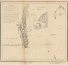
First American Map of the Bay of San Diego
Nice example of the first edition of the US Coast Survey's first mapping of San Diego Bay.
This first edition can be distinguished from the 2nd edition by the addition of the official seal of the US Coast Survey in the left of the map on the 2nd edition.
The plan of the harbor covers the area from Point Loma and La Playa in the west to Shelter Island, with extensive soundings taken. Point Loma, Ballast Point, La Playa, an Observatory, ship wreck and various buoys are noted. Larger inset diagram shows the entire bay. Extensive sailing notes in the upper left corner. One of the earliest obtainable maps of San Diego.
![[ West Mission Valley / University of San Diego / Midway / Sports Arena ] Map Showing the subdivisions in the partition suit of Steele vs. Steele, No. 5620 in the Superior Court. County of San Diego. And the allotment as made by the Referees, Surveyed by O. N. Sanford C.E. . . . Nov 1891.
Nov. 1891](https://storage.googleapis.com/raremaps/img/small/96483.jpg)
![(San Diego Panoramic Photograph) U.S. Marine Barracks [Panoramic photograph of San Diego Marine Corps Recruiting Depot (MCRD)]](https://storage.googleapis.com/raremaps/img/small/99633.jpg)
![[Oceanside and Camp Pendleton]](https://storage.googleapis.com/raremaps/img/small/71834.jpg)