|
||

|

|
|

|
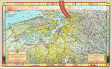
Fantastic original hand-drawn pictorial map of New Canaan, Connecticut, prepared by P.I. Camp in the 1920s or '30s.
The map shows the town of New Canaan, with many of its landmarks, such as the library, town hall, Bushy Ridge, the New Canaan Country Club, the New Canaan Country School, and others.
The image is surrounded by a carte-a-figure border of drawings of local buildings, including churches, inns, schools, etc. The border also includes two text panels, one about the initial grant of land in May of 1681, to Samuel Keeler for his service in the Indian wars. The other panel would appear to be a section from the initial town charter.
Next to the cartouche is a stylized Pilgrim holding a musket.
The presentation of the image - with multiple hand-drawn images pasted onto artist board - suggests that the map was intended to be photomechanically reproduced in print. We have been unable to find any printed copies of the map nor to deduce if any were made.
![[Japanese Invasion of Manchuria] Far East / War Fever](https://storage.googleapis.com/raremaps/img/small/63382.jpg)