|
||

|

|
|

|
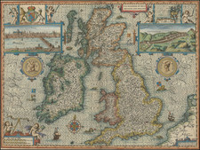
Decorative map of England, Scotland, and Wales, published in London by John Senex.
England, Scotland, and Wales are colored separately.
The map shows major roads around Great Britain, as well as a reference to the 52 counties of England.
The cartouche emphasizes the importance of the Royal Navy, with Neptune also guarding the island. The country's road network is also highlighted.
John Senex (1678-1740) was one of the foremost mapmakers in England in the early eighteenth century. He was also a surveyor, globemaker, and geographer. As a young man, he was apprenticed to Robert Clavell, a bookseller. He worked with several mapmakers over the course of his career, including Jeremiah Seller and Charles Price. In 1728, Senex was elected as a Fellow of the Royal Society, a rarity for mapmakers. The Fellowship reflects his career-long association as engraver to the Society and publisher of maps by Edmund Halley, among other luminaries. He is best known for his English Atlas (1714), which remained in print until the 1760s. After his death in 1740 his widow, Mary, carried on the business until 1755. Thereafter, his stock was acquired by William Herbert and Robert Sayer (maps) and James Ferguson (globes).
![[ Letter of Marque ] Articles of Agreement and Engagement of the Privateer or Letter of Marque the Alarm belonging unto the Island of Guernsey . . . 1798](https://storage.googleapis.com/raremaps/img/small/100233.jpg)

![[WWI British Propaganda Map in Italian] L’impero Britannico in Guerra](https://storage.googleapis.com/raremaps/img/small/86441.jpg)