|
||

|

|
|

|
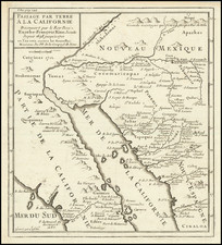
A French European Colony In Sonora and Chihuahua To Resist US Expansionism
Scarce map of the borderlands between the United States and Mexico, illustrating the colonization scheme of Frenchman Hippolyte du Pasquier de Dommartin.
The map provides a detailed topographical overview of the region. It is focused primarily on the state of Chihuahua, the focal point of Dommartin's interests. The inset map in the bottom left corner depicts the West Coast of Mexico and Baja California. It offers a wider visual representation of the location of Chihuahua and Sonora within Mexico. According to the legend, this map includes locations of indigenous ruins, presidios (both occupied and abandoned), and roads.
Dommartin was an ambitious promoter of his colonial aspirations. Taking advantage of rising concerns about American expansionism, he urged for the creation of French colonies in Sonora and Chihuahua, in his opinion a key position. Unless Europe acted soon, he thought that the United States would ultimately assume the role of absolute arbiter of the world's commerce.
The present example of the map is annotated in red, to show longitude west from Paris; the original grid below is set out from the Prime Meridian of Greenwich. The location of the Colorado River (Rio Colorado) has been added at the western edge of the Rio Gila. It also has the spelling of Stephen Watts Kearny's name corrected from the original made in 1850, which had been misspelled as Kerney.
Along the Rio Grande from Paso del Norte to Presidio del Norte, the map notes the locations of the occupied presidios in 1850, including Guadalupe a short distance downriver from Paso del Norte. The Ysleta, Sorocco and San Elizario villages on the western banks of the Rio Grande are shown. Guadalupe appears on the map with a symbol indicating it to be a military colony founded, according to De Dommartin, in 1850.
Further downriver is Pilares, noted as "Nonville Couonie" and shown to be an occupied colony. According to the Handbook of Texas, Pilares was the site of a presidio, penal colony, and silver ore smelter. While several other accounts confirm this, the Handbook article places Pilares on the Texas side of the Rio Grande.
A key at the right locates:
- Ruins of Indian Fortifications (Cliff Dwellings?)
- Inhabited Forts
- Abandoned Forts
- Towns and Villages
- Occupied Private Lands
- Abandoned Farms
- Wagon Routes
- Mule Routes
The legend below the title notes:
On sest servi pour la construction de cette Carte: 1o. des Observations faits pendant l'Expedition commandee par General Kearney et par le Lieutt. Cooke, 2c. des reconnaissances faites sur les lieux par M. H. du Pasquier de Dommartin.
The map was constructed from 1. Observations made during the Expedition commanded by General Kearney and Lieutenant Cooke, 2. Reconnaissance made on the spot by Mr. H. du Pasquier de Dommartin.
In 1846, General Kearney and Lieutenant Cooke were ordered by the United States Army to meet in Chihuahua during the Mexican-American War. During this time, and specifically on their march to El Brazito, the General and his troops were able to survey the land, information which was later used to build this map.
Hippolyte du Pasquier de Dommartin
In 1849, Frenchman Hyppolite du Pasquier de Dommartin left Le Havre for America. Arriving in New York in early March, he travelled to New Orleans and then onward toward San Francisco, part of the California Gold Rush. However, he quickly turned his attention southward.
On December 28, 1849, Dommartin petitioned the government of Chihuahua for a concession to colonize large tracts of land in Chihuahua and Sonora with European Catholics from France, Belgium, Germany, Italy and Spain. He promised to bring 25,000 settlers within five years, arguing that this would block US penetration. In addition, he requested authorization to build several railroad routes, one of which would pass through Sonora. His request was granted by the Chihuahua Congress on April 11, 1850, offering Dommartin 5000 varas for each 1,000 immigrants. It was extended on March 13, 1851; April 28, 1852, and March 27, 1853. A final extension by Santa Anna on June 27, 1853 reduced the number of settlers and removed the consent to build railroads.
Dommartin did not succeed in his undertaking, in part because of several filibuster expeditions to Sonora, which brought greater attention to the region from the federal government of Mexico.
![[Chiapas] Carta Postal de la Republica Mexicana Estado de Chiapas . . . 1934](https://storage.googleapis.com/raremaps/img/small/55436.jpg)
![Culiacanae, Americae Regionis, Descriptio [with] Hispaniolae, Cubae, Aliarumqe Insualrum Circumiacientium Delineatio](https://storage.googleapis.com/raremaps/img/small/86114.jpg)