|
||

|

|
|

|
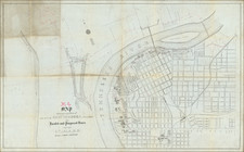
Marvelous separately published map of the City of Memphis, published by the Theo W. Ohman Map Company of Memphis, Tennessee.
The map lays out the city proper, with a detailed street index. Downtown, near the water, a number of public and private buildings, parks and other points of interest are noted. Railroad lines are located in a thick black lines, with street car lines in dashed lines.
Contains various data and names landowners provided by Bluff City Abstract Co. In the city itself, the map highlights and names parks, streets, public buildings, churches, cemeteries, the zoo and schools, including the West Tennessee State Normal School (current-day University of Memphis).
Near the bottom, in P8, exists a Colored Orphans Home. Outside the city limits, it shows property tracts with owners' names and acreages. Included in these is a tract of land owned by Clarence Saunders, the founder of Piggly Wiggly supermarkets, who built the Pink Palace in this location just a couple years prior.