|
||

|

|
|

|
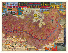
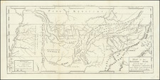
Lively pictorial map of Tennessee, published by the Division of State Information Department of Conservation.
Marvelous whimsical imagery, highlighting places of interest, indigenous industries, etc.
A note next to the title states that "The cartoons appearing on this map were superimposed on an actual highway map. . . . "
Rumsey notes:
Date estimated based on the presence of The American Museum of Atomic Energy which opened in 1949. Shows roads, highways, rivers, major cities and towns. Numerous cartoon vignettes illustrating landmarks, agricultural products, recreational activities, animals, etc. Relief shown pictorially. On recto of cover: includes lists of parks, recreational and historic areas, Tennessee fishing lakes, Cities of Tennessee, and Mountains of Tennessee. On verso: Itineraries for 33 road trips.
![[Maximum Berkeley] A Map of Berkeley, Oakland & Alameda](https://storage.googleapis.com/raremaps/img/small/50325.jpg)