|
||

|

|
|

|
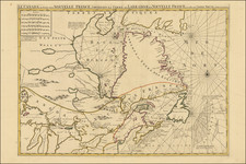
Rare Dutch Map of the Northeast Showing All The Dutch Names From the 17th Century
Fine example of this extremely rare map of the New Netherlands of the Dutch West India Company, also including the Swedish settlements of Usselinx on the Delaware.
The map illustrates the original Dutch (and occasional English) place names throughout the region. As noted below, the authors of the map created this map as part of an academic competition held in 1822 by the Provincial Utrecht Society (PUG) to promote the Dutch contribution to the voyages of discovery. To this end, Van Wijk made an initial inventory of the names given by Dutch people all over the world, as well as the current name and relevant details. To compile this information, it is believed that they worked through all kinds of ship logs. In 1825, they were awarded first prize and, with support from the PUG, their winning entry was also printed and published in 1827. Following publication of the first work, they also compiled an atlas of maps in 1829, of which this is one of the maps.
Published Treatise and Atlas
The map was published in the atlas accompanying a monograph on the Dutch settlements in various parts of the world, entitled Atlas behoorende tot de Verhandeling van R.G. Bennet en J. Van Wijk, Roelandsz, wegens de Nederlandsche ontedekkingen, bekroond door het Provincial Utrechtsch genootscahp van kunsten en wetenschappen en opgedragen aan hetzelve genootschap. (Translation: Atlas belonging to the Treatise of R.G. Bennet and J. Van Wijk, Roelandsz, for the Dutch discoveries, awarded by the Provincial Utrecht Society of Arts and Sciences and dedicated to the same society).
The atlas accompanied a work entitled: Verhandeling over de Nederlandsche ontdekkingen in Amerika, Australie, de Indien en de Poollanden, en de namen, welke weleer aasn deszelve door Nederlanders zijn gegeven . . . (Translation: Treatise on the Dutch discoveries in America, Australia, the Alsace and the Polar countries, and the names formerly given to them by the Dutch. . .)
Rarity
The Atlas is extremely rare. We were unable to locate and example offered for sale in the past 100 years.
Jacobus van Wijk was a boarding school keeper and Geographer.
He opened the Van Wijk Institute in the town of Hattem in May 1817, a boarding school which taught geography, history, physics, geometry and astronomy.
In his spare time, he pursued scholarship. Surrounded by books, maps, globes and instruments, he regularly picked up his pen there. Already in his early years he had written a lot. For example, the first volume of Handboek der Aardrijkskunde (1807), with second volume published in 1821 and and three part Nieuwe handleiding tot de aardrijkskunde (1818-1826).
It was this latter work that introduced him to retired navy officer Roelof Gabriël Bennet (1774-1829), who lived in Hattem. In 1822, the pair submitted a paper on the History of Dutch Explorations around the World in a competition organized by the Provincial Utrecht Society. After being given the opportunity to improve their treatise, they were awarded a gold medal for it in 1825 and offered membership of the society. The award-winning treatise of the two geographers was finally published in 1827, entitled Onder de titel Verhandeling over de Nederlandsche ontdekkingen in Amerika, Australië, de Indiën en de Poollanden, en de namen, welke weleer aan dezelve door Nederlanders zijn gegeven, werd uiteindelijk (Treatise on the Dutch Discoveries in America, Australia, the Indies and the Polar Countries, and the names formerly given to them by the Dutch).
In 1828, van Wijk and his son relocated to Kampen to run a school in that city.
![(American Revolution) [Manuscript Map of New York City and Northern New Jersey]](https://storage.googleapis.com/raremaps/img/small/69609.jpg)
![[ New York Harbor ] Entree de la Riviere D'Hudson depuis la Pointe Sandy Hook jusqu'a New York les Bancs, les Sondes les Guides &c. . . 1778](https://storage.googleapis.com/raremaps/img/small/78970.jpg)