|
||

|

|
|

|
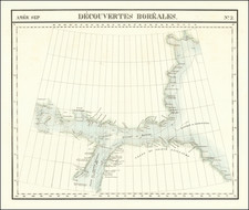
This is a fantastic map of Antarctica, published at a time when the outline of the continent was just starting to take shape. Parts of the exterior of the continent are shown in detail, though the interior of the vast continent is little described.
The map names many places of interest throughout the continent. Some areas are well mapped, such as the Ross Ice Shelf, the Peninsula, and the South Shetland Islands. Other parts of the island, such as the Enderby Quadrant, now Enderby Land, are barely mapped, with only bits of the coastline appearing. The extent of pack ice in various winters is noted, providing a fascinating look at how the Antarctic ice shelf changes from season to season. A "Probable Extreme Limit of Pack Ice" is labeled.
The routes of dozens of explorers are traced throughout the map. These stretch in time from the circumnavigation of the South Sea by Cook to Amundsen's and Cook's journeys to the pole in the winter of 1911-12. The farthest point reached by Shackleton in 1909 is marked.
This map appeared in the 1922 edition of the Times Atlas, reissued from the 1920 edition to include Bartholomew's maps. This Atlas is still published today and continues to be a source of cutting edge knowledge.