


|
||

|

|
|

|
A Previously Unknown Wall Map of The World
Remarkable large map of the World, printed for The Society for the Propagation of the Gospel, in London, July 1, 1842.
The map is noteworthy for its clean and uniformly minimalist approach to cartographic detail, allowing for a clean and uncluttered look at the mountains, rivers, cities, settlements and other primary information, and eschewing conjecture and speculation. The map includes an excellent treatment of the known lands in Antarctica
The present example seems to be a unique survival. We have been unable to locate any other record of a surviving example of the map. The map was likely intended as a companion an atlas published in the same year by the society and "drawn and engraved by J. Archer,", entitled A Church Atlas, containing maps of the Colonial dioceses with geographical and statistical tables, with preface by Ernest Hawkins, the Society's secretary.
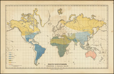
The map is color coded to show:
- English Possessions: Red
- Christian Countries: Blue
- Heathan Countries: Yellow
- Mahometan Countries: Green
At the top center, a table showing Colonial Bishoprics appears. At the bottom center is a table showing "Colonial and Foreign Dependencies of Great Britain," including population, square miles, date of acquisition and number of clergy. A smaller table to the left shows world statistics, including the populations of the world by religion:
- Christians - 260 Million
- Jews - 4 Million
- Mahometans - 96 Million
- Idolaters - 500 Million
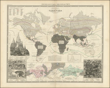
Includes a colorful vignette showing the relative heights of the world's mountains and volcanos, with a key on either size identifying the moutains, with Western Hemisphere at the left aand Eastern Hemsphere at the right. A second vignette, opposite left, shows the lenghts of the world's longest rivers, with the Missouri/Mississippi River being the longest in the world.
Rarity
The map is extremely rare and quite possibly unrecorded. A very similar single sheet folio map appears to have been included in the Church Atlas ... , as illustrated here, which has a slightly different title ("and" instead of "&").
https://nla.gov.au/nla.obj-232358368/view
We note examples of the smaller map at the New York Public Library, National Library of Australia, National Library of New Zealand and British Library. We note an 1850 exampleof the smallermap at the Australian National Library and an undated example at the State Library of Queensland.
![[ Hesiod's World Map ] Hesiodische Welt-Tafel von I.H. Voss](https://storage.googleapis.com/raremaps/img/small/102650.jpg)