|
||

|

|
|

|
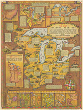
First State of the Second Map of Milwaukee, with Contemporary Property Ownership Annotations.
This is an exceedingly rare early map of Milwaukee, made by the important Milwaukee cartographer Increase Lapham. This is the first printed map to show a complete picture of Milwaukee, and the second printed map of the city. This map preserves the city as it stood during its early days, a fascinating period almost without rival in any other major American city.
The map shows neighborhoods, streets, property ownership for larger blocks of land, and several other important features in the city. Street blocks are numbered, and the acreage of other lands are noted. Some early roads are named.
The map is important as it is the first to show the true layout of Milwaukee (and only the second traced map of the city). The "first" map of Milwaukee only showed "Kilbourntown," that is, lands west of the Milwaukee River and north of the Menomonee River. This was the area that had been developed by Byron Kilbourn, and he had wanted to promote his land at the expense of Juneau town and Walker's Point and so commissioned the map. Underhanded techniques abounded during this time from all sides and, with this map omitting two-thirds of the city being just one of the many cases of intrigue.
Notable is the complete lack of bridges on the map, with the only feature spanning the Milwaukee River being a small dam to the north. This is, without a doubt, intentional. The Milwaukee Bridge War (discussed below) was at its peak in 1845, with residents from both sides of the river destroying bridges and attacking over-river residents on a regular basis. After the War cooled down, three new bridges were built. This map was almost certainly related to this conflict and perhaps served to aid in the decision regarding where to put the new bridges.
The map records the plots owned by four early landowners in "Kilbourntown" section of Milwaukee. The four owners are "B. Comstock + co." (yellow); "B. Kilbourn" (green); "J M Mc Carty" (pink); "M.T. Williams" (blue).
The map was engraved by Sherman & Smith in New York, and designed by Increase Lapham. Lapham was an important figure of the early Midwest, having been an early resident of Kilbourntown since 1836. He is thought to have published the first scientific work west of the Great Lakes and was an important naturalist who helped in the founding of the National Weather Bureau.
The Milwaukee Bridge War of 1845
The streets in Kilbourn's map are somewhat offset from those in Juneautown. The effects of this can be seen on modern maps of downtown Milwaukee, where the streets on the east and west sides of the river do not match up. This became a major issue in 1840 when the Wisconsin Territorial Legislature ruled the city's ferry network inadequate for the growing city and ordered a bridge to be built. By 1844 a total of four bridges had been built across the Milwaukee River. Three of the bridges (at Chesnut, Oneida, and North Water) were opposed by Kilbourn as they encumbered water access to his docks.
On May 3rd, 1845, a schooner crashed into the bridge at Spring Street, which had been supported by Kilbourn and the West Ward. Rumors spread among the East Ward residence that Kilbourn had arranged for the accident to happen. The West Warders then took it upon themselves to destroy the Chestnut Street bridge (support by Juneau and his faction), which they called a nuisance to water traffic. After the West Warders collapsed the western section of the Chestnut Bridge, East Warders gathered weaponry, including an old cannon, and brought them to bear on the west bank. Before they fired on the west bank, word spread that Kilbourn's young daughter had just died and cooler heads prevailed.
The rivalry that had built for ten years dissipated over the remainder of 1845, and, in 1846, plans for three new bridges were drawn up. On January 31st, 1946 a city charter was drawn up and the City of Milwaukee was officially incorporated.
Manuscript Annotations
As noted, property belonging to four early citizens and entities of Milwaukee is demarcated in the west of the map. While we have been unable to trace three of these, the fourth, B. Kilbourn, was one of the most important figures in early Wisconsin history. Byron Kilbourn, namesake of Kilbournstowne, was one of the drivers and primary participants in the Milwaukee Bridge War. Descended from a prominent Connecticut family, he moved to Ohio to work as a surveyor. He would found Kilbourntown in 1837 to rival the already existing Juneautown, and would later help to incorporate Milwaukee in 1846. His scheming career would not serve him well however, he was repeatedly accused of fraud and became a central figure in a large early Wisconsin bribery ring.
It is worth considering who annotated this map. They must have had detailed knowledge regarding prominent landowners in Kilbourntown and were perhaps affiliated with one of the four names on the map. Within the context of the Milwaukee Bridge War, these landowners (and others) would have wanted the placement of any new bridges to be of utmost value to them, which may have provided an impetus for so annotating the map.
States and Rarity
Rumsey (3033) notes in his description of the 1856 edition:
1st issue was in 1845, issued every year until 1869. This copy is uncolored and folded twice. Usually, this appeared as a pocket map. Lapham also issued, with Colton, a larger map of Milwaukee and with Van Slyck (a printer in Milwaukee) a smaller map of the city in 1854. The first map of Milwaukee listed by Karrow is an 1836 map attributed to Lapham, then the first edition of this map in 1845. Phillips' first listing is a later edition of this map in 1857.
We note only Rumsey's later example of this map, and this is the only example we have been able to locate.
![[ Superior, Wisconsin ] The Next Great City Watch Us Grow Superior](https://storage.googleapis.com/raremaps/img/small/99914.jpg)