|
||

|

|
|

|
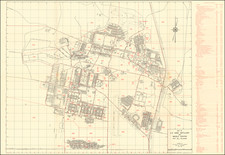
El Reno The 'Hub' of Oklahoma Territory and the Gateway and Distributing Supply Point for the Cheyennes & Arrapahoes
Rare early map of the city of El Reno, Indian Territory, published in 1891, on the eve of the Third Oklahoma Land Rush (April 19, 1892), which opened up the western part of the city to American settlers.
The maps text extolls the virtues of "El Reno The Great Railroad Centre and Future Capital of The Territory . . . [with] Pure Water, Healthy Climate, Energetic People and The Finest and Best Kept Hotel In The Territory, Hotel Caddo." The intent is made clear that "The Great Rock Island Railway Co. is largely interested, in Realty, In El Reno, and they are determined to make it a city of the first class." The map praises and promotes the prospects for investors and settlers with the
Below the main map, a regional map shows El Reno within Canadian County. To the right is wider regional map covering all of Oklahoma and Indian Territory and neighboring regions, centered on El Reno.
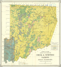
Named for the neighboring Fort El Reno, the town of El Reno was established in 1889, located at the western edge of the so-called Unassigned Lands. The Unassigned Lands were in the center of the lands ceded to the United States by the Creek (Muskogee) and Seminole Indians following the Civil War and on which no other tribes had been settled. By 1883 it was bounded by the Cherokee Outlet on the north, several relocated Indian reservations on the east, the Chickasaw lands on the south, and the Cheyenne-Arapaho reserve on the west. In 1889 this territory was offered by the federal government to non-Native Americans for settlement in the Oklahoma Land Rush.
The present map was published shortly before the Land Run of April 19, 1892. El Reno is located on the 98th meridian west, which allowed the eastern side to be opened to non-Indian settlement in the Land Rush of 1889. The western side (Cheyenne and Arapaho lands), was opened as part of the third Oklahoma Land Rush in April, 1892. El Reno was subsequently selected as the land district office for the 1901 land lottery drawings
By 1907, a permanent Rock Island Railroad Depot had been built.
El Reno
El Reno had a controversial beginning. This town began in 1889 and was not legally straightened out until 1892. John Foreman located cattle trails for the railroads and assisted in running a line from Kansas to El Reno in the 1880s. in the 1889 land run he homesteaded NW1/4 9 – 12 – 7. Foreman filed a soldier’s declaratory statement on it. He also signed a homestead affidavit stating that the entry was “for the purpose of actual settlement for his own benefit and not for other people.” On May 13, two days after filing his homestead, Foreman took a four-day trip. Upon his return he found a group of men surveying and laying out a town. They advised him to lease a portion of his homestead to the townsite company. On May 19, he leased 120 acres to the Oklahoma Homestead and Town Company, keeping 40 acres to cultivate for himself.
The Territorial Act of May 2, 1890 made provisions for the incorporations of towns. On June 11th a petition was submitted to the county commissioners. They ordered the 120-acre tract of Foreman and the adjoining 80 acres of Thomas Jensen be incorporated as the “Village of El Reno.” Anson A. Davis, a homesteader near Frisco, charged Foreman was a “sooner” and worked for the townsite company. The Commissioner of the General Land Office ruled in favor of Foreman. Davis then appealed the decision to the Secretary of the Interior. The matter was also taken to the U. S. Congress. On February 6, 1892 John W. Noble, Secretary of the Interior handed down this decision. He directed that the homestead and cash entries made by Foreman, be cancelled and the land be entered under the townsite law.
About noon the same day an El Reno citizen received a private message about Mr. Noble’s decision. The Foreman land was opened for public settlement. About 9:00 p.m. lot jumpers moved on the land and in about an hour almost every lot was occupied. Adjoining homestead entries of Thomas Jensen and James Thompson were cancelled on November 26, 1892. John Foreman relinquished to the U. S. Government all his right, title and interest in the tract of land he had claimed as a homestead on August 1, 1893. Thus, the first clear title was secured by the city of El Reno in 1893.
El Reno’s early history was unique in another way. It had a part in three different land openings. The east part of the town was established in the 1889 land run. Grand Street was on the edge of the 98th Meridian, which was the west boundary of this land run. Many more people came to El Reno to make the run into the Cheyenne and Arapahoe lands in April 1892. This opened the land which became the western part of El Reno. The 1901 land drawing was held in El Reno. That summer the town was host to thousands of hopeful people wanting land.
Rarity
The map is extremely rare. We have been unable to locate another example in a dealer catalog or at auction.
OCLC locates 2 copies (Yale and SMU De Golyer Library).
![Mapa et tierra q[u]e yos pedro Vial taigo transitau en St. Tafee este dia 18 de Octubre de La ao 1787](https://storage.googleapis.com/raremaps/img/small/3645.jpg)
![[ Colorado ] [ Indian Territory on verso ]](https://storage.googleapis.com/raremaps/img/small/101102.jpg)