|
||

|

|
|

|
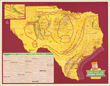
An Early Wall Map of Austin, Texas -- Includes Contemporary Developer's Annotations
Rare promotional plat map of Austin, Texas, published by the Bergen, Daniel & Gracy Abstract Title Company.
Fine cadastral map identifying dozens of land owners in central Austin and the surrounding areas. Includes a large view of Austin Dam, "For Water, Light & Power." The Austin Dam only lasted about another decade, failing in 1900, killing dozens of people in the process, and leaving Austin without power for months.
"Texas University" appears with a footprint of the "Main Building." This would be UT Austin, founded 8 years earlier in September of 1883.
The map credits John F. Pope and Reuben Ford as the primary source, noting that the map is the result of sixteen years' work and highlights the "position and advantages of many additions existing and projected near the city, the Dam and Lake, the seat of present activity and the mountain hights [sic] soon to be crowned with residences and hotels for the traveler intent on health or pleasure."
Annotations
The present example of the map has several notes added. The first note traces the Dam Railroad to its terminus east of the Dam, then shows what is labeled faintly in red as "extension" of the Railroad through a 100 acre parcel owned by Wm. Walsh, with an annotation stating "subdivided" into a 33 1/3 acre lot and an 66 acre lot. This likely relates to the future extension of the Railroad, which occurred in 1895. A second note to to the left at the margin notes: " "R.R. as water exists in time proposed," and is signed by "S.S. Griffith". S.S. Griffith was a local real estate agent in Austin, who seems to have been active from 1888 to 1897, originally coming from Shelbyville, Kentucky. In 1890, he was advertising as a member and director of the Austin Real Estate Exchange.
A second annotation shows a faint red rail path from the dam into downtown which ends with hand drawn dash marks running north from 4th street up Congress Ave., taking a right on 11th street and then north up San Jacinto. These marks proposed extending a rail service to run conveniently north and south past the Capitol Building.
A third annotation consists of a pencil inscription outlining land belonging to "R.M. Hall et al.," and "Stalks (?) " in plot 27 and Dowells (?) in plot 51, and north of the Capitol.
The Austin Dam Railroad was originally built by the city of Austin in 1891 and ran from the city to the site of Austin Dam, a distance of 4.75 miles. The Austin Dam and Suburban Railway was chartered on July 16, 1895, and purchased the line from the city of Austin for $43,500. The railroad was electrified and operated as a streetcar line through Austin to a pleasure park near the dam. In the spring of 1899 an additional 1.5 miles of track was constructed.
Rarity
No copies in OCLC, the Library of Congress, or the Texas State Archives.
We note that Richard B. Arkway offered an example with advertising for $12,000 in its Catalog 69, in 2009.
This is the second example of the map we have offered in more than 20 years.
![[ Oil & Gas in Texas and Louisiana ] Gulf Coastal Region Texas and Louisiana Showing Oil, Gas & Sulphur Fields & Prospects Pipe Lines & Refineries](https://storage.googleapis.com/raremaps/img/small/101409.jpg)
![(Texas - Apache Depredations in Mexico) Discurso Que Pronunció el señor Coronel D. José Joaquin Calvo, Comandante general del Estado de Chihuahua, al entrar en ejercicio del Supremo Poder Ejecutivo del mismo [caption title]](https://storage.googleapis.com/raremaps/img/small/93111.jpg)