|
||

|

|
|

|
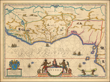
This is a decorative regional map from Scherer's monumental Jesuit inspired work. Africa is shown northwards of the mythological source lakes of the Nile, with extensive, though often fantastical, detail. The map includes a decorative cartouche showing the fauna of the continent. Detail extends into Arabia and southern Europe. In all, this is a very nice map.
Numerous rivers and lakes crisscross the map. Even in the Sahara, large bodies of water can be found. Lake Zaire sources both the White Nile and an unnamed river which appears to be the Congo. Many cities, mountain ranges, islands, and other features can also be located.
This work was published in Scherer's Atlas Novus, a monumental Jesuit inspired work. Scherer, himself a Jesuit, published this seven-volume work containing some one hundred and eighty maps. The work is notable for its Catholic imagery, a reaction against the protestant Dutch cartography which dominated of the rest of the 17th century. Scherer eschews symbols of trade and pagan history for religious or natural imagery in many of his pieces. The maps in the Atlas were engraved by Leonard Hecknaeur, Joseph Montealegre, and Matthus Wolfgang.
![[ Ethiopia, Sudan & Eritrea ] Nubia and Abysssinia](https://storage.googleapis.com/raremaps/img/small/101736.jpg)