|
||

|

|
|

|
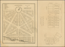
Large bird's-eye view of Marquette, Michigan, drawn by E. Demar and lithographed by Beck & Pauli in 1886.
The view illustrates the booming city of Marquette, with 9 major piers and wharfs. The map shows the town from the south side of the Harbor, and includes a fine general view of the city, along with smaller images including the residences of a number of prominent citizens and views of
- Upper Peninsula Brewing Co, Meeske & Hoch Proprietors
- European Hotel
- First National Bank
- Wolf and Jacobs Stone Quarry
- M.E. Church
- Mining Journal
- St. Paul's Episcopal Church,
- High School
- Mesnard Hotel
- Marquette, Houghton and Ontanagon RR Ore Docks
- St. Peter's Cathedral
- Presbyterian Church
- W.R. Wright Store
- Iron Bay Mf. Co.
- CH Call and Co. Store
- Smith Moore (ship)
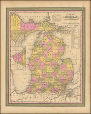
- geographical map of Michigan and it's surroundings.
A key, arrayed between the vignettes, locates an additional 72 points of interest on the map.
The Peninsula Brewing Company was the second oldest Brewery in the Upper Peninsula. It had been founded bvy Nickolas Voelker and a Mr. Etty in 1869. In 1870 they sold to George C. Shelden, who rand the business until about 1875. The Brewery was shuttered for several years, until its reopening by Frank Leibenstein, who in term sold the company to Charles Meeske and Reiner Hoch in May 1881. Meeske and Hoch had previously acquired the Concordia Brewery (originally called the Franklin Brewery) in 1878. Within a decade, the two would be merged into the Upper Peninsula Brewing Company, which would thrive until prohibition in 1918. After prohibition, Hoch continued operating the Duluth Brewing and Malting Company, which Meeske retired to San Diego.
Marquette is the largest city in the Upper Peninsula of Michigan, and, at the time the view was made, it had eyes on becoming one of the major ports on Lake Superior. The view was made during the heyday of the iron ore industry in the Upper Peninsula, and aside from its importance as a transshipment port for ore, Marquette also marketed itself as a summer vacation destination.
This would seem to be the second of 2 views by Beck & Pauli, pre-dated by a smaller view by J.J. Stoner and published by Beck & Pauli in 1881 (30 x 18 inches), in the collection of the Marquette County Historical Society and Clarke Historical Library (University of Central Michigan).
Rarity
The view is extremely rare.
OCLC locates 2 examples of the view in the Marquette Historical Society and the Michigan Historical Foundation.
We have been unable to locate any other examples of this view at auction or in dealer catalogs.
We also found a reference to the view as item #7743 in Maps and atlases. Manuscripts in the Burton Historical Collection, Michigan Historical Commission, 1921.